Achibakh Mountain
Achibakh or Achibakhi (Georgian: აჩიბახი) is a mountain in Abkhazia. Height 2376 m.[2] The highest peak of the plateau Rykhva. On the map of Abkhazia, issued in 2009 by the Geographical Society of Abkhazia,[3] the mountain is called Arttara.
| Achibakh Mountain | |
|---|---|
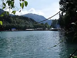 View of Mount Achibakh from the Lake Ritsa. | |
| Highest point | |
| Elevation | 2,376 m (7,795 ft) |
| Coordinates | 43°25′07″N 40°34′57″E |
| Geography | |
 Achibakh Mountain Location of the mountain | |
| Country | Abkhazia[1] |
| Parent range | Gagra Range |
Geography
The limestone mountain rises above the karst fields, in which there are many caves. One of the largest caves is the Quartet mine (-340 m). The highest point in the vicinity is Mount Agepsta northwest of mountain Achibakhi.
Flora
Mixed forest and subalpine (tree line) endemic flora grows on the mountain.
See also
- Achibakh Range
References
- The political status of Abkhazia is disputed. Having unilaterally declared independence from Georgia in 1992, Abkhazia is formally recognised as an independent state by 5 UN member states (two other states recognised it but then withdrew their recognition), while Georgia continues to claim it as part of its own territory, designating it as Russian-occupied territory.
- Mta Achibakhi 2376 m GeoNames
- Geographical Society of Abkhazia was established in 2001
This article is issued from Wikipedia. The text is licensed under Creative Commons - Attribution - Sharealike. Additional terms may apply for the media files.