New Bloomfield, Pennsylvania
New Bloomfield is a borough in, and the county seat of, Perry County, Pennsylvania, United States. It is part of the Harrisburg–Carlisle metropolitan statistical area. The population was 1,244 at the 2020 census.[4]
New Bloomfield, Pennsylvania | |
|---|---|
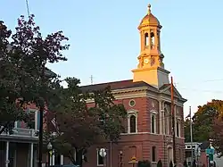 Perry County Courthouse | |
 Location of New Bloomfield in Perry County | |
 New Bloomfield  New Bloomfield | |
| Coordinates: 40°25′06″N 77°11′18″W | |
| Country | United States |
| State | Pennsylvania |
| County | Perry |
| Settled | 1824 |
| Incorporated | 1831 |
| Area | |
| • Total | 0.61 sq mi (1.58 km2) |
| • Land | 0.61 sq mi (1.58 km2) |
| • Water | 0.00 sq mi (0.00 km2) |
| Elevation [2] (center of borough) | 675 ft (206 m) |
| Highest elevation [2] (northern boundary) | 1,000 ft (300 m) |
| Lowest elevation [2] (southeast corner by Little Juniata Creek) | 640 ft (200 m) |
| Population | |
| • Total | 1,219 |
| • Density | 1,995.09/sq mi (770.78/km2) |
| Time zone | UTC-5 (Eastern (EST)) |
| • Summer (DST) | UTC-4 (EDT) |
| Zip Code | 17068 |
| Area code | 717 |
| FIPS code | 42-07040 |
| Website | http://www.bloomfieldboro.org/ |
History
New Bloomfield was laid out in 1823, and named for the blooming clovers near the original town site.[5] A post office called New Bloomfield has been in operation since 1825.[6]
.jpg.webp) New Bloomfield, 1913
New Bloomfield, 1913
Geography
According to the U.S. Census Bureau, the borough has a total area of 0.5 square miles (1.3 km2), all land.
The borough is also surrounded on all sides by Centre Township.[7]
Demographics
| Census | Pop. | Note | %± |
|---|---|---|---|
| 1840 | 412 | — | |
| 1850 | 581 | 41.0% | |
| 1860 | 661 | 13.8% | |
| 1870 | 655 | −0.9% | |
| 1880 | 673 | 2.7% | |
| 1890 | 737 | 9.5% | |
| 1900 | 772 | 4.7% | |
| 1910 | 762 | −1.3% | |
| 1920 | 778 | 2.1% | |
| 1930 | 730 | −6.2% | |
| 1940 | 858 | 17.5% | |
| 1950 | 1,098 | 28.0% | |
| 1960 | 987 | −10.1% | |
| 1970 | 1,032 | 4.6% | |
| 1980 | 1,109 | 7.5% | |
| 1990 | 1,092 | −1.5% | |
| 2000 | 1,077 | −1.4% | |
| 2010 | 1,247 | 15.8% | |
| 2020 | 1,244 | −0.2% | |
| 2021 (est.) | 1,248 | [4] | 0.3% |
| Sources:[8][9][10][11][3] | |||
As of the census[9] of 2000, there were 1,077 people, 396 households, and 255 families living in the borough. The population density was 1,983.1 people per square mile (770.1/km2). There were 425 housing units at an average density of 782.6 per square mile (303.9/km2). The racial makeup of the borough was 98.89% White, 0.56% African American, 0.28% Native American, and 0.28% from two or more races. Hispanic or Latino of any race were 0.56% of the population.
There were 396 households, out of which 29.8% had children under the age of 18 living with them, 51.0% were married couples living together, 9.6% had a female householder with no husband present, and 35.4% were non-families. 31.6% of all households were made up of individuals, and 15.2% had someone living alone who was 65 years of age or older. The average household size was 2.25 and the average family size was 2.84.
In the borough, the population was spread out, with 19.9% under the age of 18, 9.3% from 18 to 24, 24.6% from 25 to 44, 21.4% from 45 to 64, and 24.9% who were 65 years of age or older. The median age was 42 years. For every 100 females, there were 90.6 males. For every 100 females age 18 and over, there were 93.9 males.
The median income for a household in the borough was $39,018, and the median income for a family was $47,500. Males had a median income of $30,781 versus $24,286 for females. The per capita income for the borough was $17,168. About 6.0% of families and 7.6% of the population were below the poverty line, including 10.3% of those under age 18 and 6.1% of those age 65 or over.
Arts and culture
The Perry County Courthouse in New Bloomfield is listed on the National Register of Historic Places.[12]
References
- "ArcGIS REST Services Directory". United States Census Bureau. Retrieved October 12, 2022.
- "New Bloomfield Topo Map, Perry County PA (Newport Area)". TopoZone. Locality, LLC. Retrieved 26 November 2019.
- "Census Population API". United States Census Bureau. Retrieved Oct 12, 2022.
- Bureau, US Census. "City and Town Population Totals: 2020-2021". Census.gov. US Census Bureau. Retrieved 12 July 2022.
- Jordan, John Woolf (1913). A History of the Juniata Valley and Its People. Lewis Historical Publishing Company. p. 221.
- "Perry County". Jim Forte Postal History. Retrieved 29 January 2017.
- "Explore Census Data". data.census.gov. Retrieved 2022-10-23.
- "Census of Population and Housing". U.S. Census Bureau. Retrieved 11 December 2013.
- "U.S. Census website". United States Census Bureau. Retrieved 2008-01-31.
- "Incorporated Places and Minor Civil Divisions Datasets: Subcounty Resident Population Estimates: April 1, 2010 to July 1, 2012". Population Estimates. U.S. Census Bureau. Archived from the original on 11 June 2013. Retrieved 11 December 2013.
- "Census of Population and Housing". Census.gov. Retrieved June 4, 2016.
- "National Register Information System". National Register of Historic Places. National Park Service. July 9, 2010.
External links
Municipalities and communities of Perry County, Pennsylvania, United States | ||
|---|---|---|
| Boroughs |  | |
| Townships | ||
| Unincorporated communities | ||