Browns Summit, North Carolina
Browns Summit (sometimes called Brown Summit) is a small unincorporated community in Guilford County, North Carolina, United States.
Browns Summit, North Carolina | |
|---|---|
 Browns Summit  Browns Summit | |
| Coordinates: 36°12′45″N 79°42′49″W | |
| Country | United States |
| State | North Carolina |
| County | Guilford |
| Elevation | 805 ft (245 m) |
| Time zone | UTC-5 (Eastern (EST)) |
| • Summer (DST) | UTC-4 (EDT) |
| ZIP code | 27214 |
| GNIS feature ID | 982041 |
The community remains rural, consisting of wooded areas and a mixture of open meadows and rolling farmland, however, it is a growing and upcoming area due to the proximity to Greensboro, Burlington, and Reidsville as well for a number of other reasons: recognition of the state's plan to complete Interstate 785 near the area; the new housing developments in progress, particularly along the western area near NC Hwy 150 and Yanceyville Road; the Bryan Park Complex, located at the town's Southern boundary (Bryan Park features the BB&T Soccer complex, Lake Townsend Park (adjacent to the eponymous lake), and the Champions Golf Course), as well as the handful of major factories located in the Bryan Park complex close to the Summit Avenue corridor. Once the Greensboro Urban Loop is completed, the southern reaches of Browns Summit will be in proximity to the loop.
History
Jesse Brown acquired the land in the area in 1858 and established a farm. In 1863, the Richmond and Danville Railroad built a line through the area and named it Browns Summit, as Brown's farm rested at the highest point of elevation on the line.[1]
Geography
Browns Summit is located in northern Guilford County and rests at an altitude of 805 feet above sea level.[1]
References
- Powell 1976, p. 66.
Works cited
- Powell, William S. (1976). The North Carolina Gazetteer: A Dictionary of Tar Heel Places. Chapel Hill: The University of North Carolina Press. ISBN 9780807812471.
Municipalities and communities of Guilford County, North Carolina, United States | ||
|---|---|---|
| Cities | 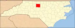 | |
| Towns | ||
| CDPs | ||
| Unincorporated communities | ||
| Footnotes | ‡This populated place also has portions in an adjacent county or counties | |