Canal through Zuid-Beveland
The Canal through Zuid-Beveland (Dutch: Kanaal door Zuid-Beveland) in the southwest Netherlands is the westernmost of two canals crossing the Zuid-Beveland peninsula. It connects the Western Scheldt near Hansweert (to the south of the canal) via sluices and the Eastern Scheldt (to the north) has an open connection.
| Canal through Zuid-Beveland | |
|---|---|
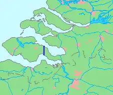 The route of the Canal through Zuid-Beveland | |
| Country | Netherlands |
| Specifications | |
| Length | 9 kilometres (5.6 miles; 4.9 nautical miles) |
| Lock length | 280 m (919 ft) [1] |
| Lock width | 24 m (79 ft) |
| Maximum boat length | 200 m (656 ft) [2] |
| Maximum boat beam | 23.5 m (77.1 ft) |
| Maximum boat draft | 4.8 m (15.7 ft) (depending on the tide) |
| Maximum boat air draft | 44 m (144 ft) (due to power lines) |
| Locks | 1 x 2 (originally 2 x 3) |
| Status | operational |
| History | |
| Construction began | 1850 |
| Date completed | 1866 |
| Geography | |
| Start point | Eastern Scheldt river, Netherlands |
| End point | Western Scheldt river, Netherlands |
| Beginning coordinates | 51°31′10″N 4°0′56″E |
| Ending coordinates | 51°26′21″N 4°0′39″E |

Aerial view of the Canal through Zuid-Beveland, showing north side of the canal

Railroad bridge over the Canal through Zuid-Beveland

Canal through Zuid-Beveland (south side), showing entrance to the locks
The canal is crossed by a movable railroad bridge (between the railroad stations Kapelle-Biezelinge on the west and Kruiningen-Yerseke on the east), a motor-road tunnel (the Vlake Tunnel in the A58 motorway) and two movable road bridges.
Additionally, at the south side the canal has two parallel sluices that can carry road traffic, but are just accessible by pedestrians, cyclists and horseman.
References
This article is issued from Wikipedia. The text is licensed under Creative Commons - Attribution - Sharealike. Additional terms may apply for the media files.