Darel District
The Darel District (Urdu: ضلع داریل) is a district in Gilgit-Baltistan territory of Pakistan.[1] It is located towards south-west of Gilgit District.[2] Its population lives mainly in the valley of the Darel River, a right tributary of the Indus River.[3]
Darel District
ضلع داریل | |
|---|---|
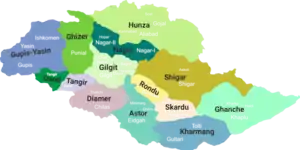 District map of Gilgit-Baltistan[lower-alpha 2] | |
| Country | |
| Territory | |
| Division | Diamer Division |
| Headquarters | Darel |
| Government | |
| • Type | District Administration |
| • Deputy Commissioner | N/A |
| • District Police Officer | N/A |
| • District Health Officer | N/A |
| Languages | |
| • Official language | Urdu |
| Number of tehsils | 1 |
History
Prior to 2019, the Darel District was a tehsil of the Diamer District, along with Tangir and Chilas.
Geography
The Darel District is bounded on the north by the Ghizer District, on the north-east by the Gilgit District, on the east and southeast by the Diamer District, and on the south and west by the Upper Kohistan District of Pakistan's Khyber Pakhtunkhwa Province,
Notes
- On the map, the Darel District is incorrectly shown as Tangir and vice versa.
- On the map, the Darel District is incorrectly shown as Tangir and vice versa.
References
- "GB notifies four more districts, total number of districts now 14". pakistantoday.com.
- "Administrative Reforms: Gilgit-Baltistan govt issues notification of four new districts". pamirtimes.net.
- Darel River, OpenStreetMap, retrieved 22 January 2022.
This article is issued from Wikipedia. The text is licensed under Creative Commons - Attribution - Sharealike. Additional terms may apply for the media files.