Fairplay, Colorado
The historic Town of Fairplay is the Statutory Town that is the county seat and the most populous municipality of Park County, Colorado, United States.[1][7] The town population was 724 at the 2020 United States Census.[4] Fairplay is located in South Park at an elevation of 9,953 feet (3,034 m). The town is the fifth-highest incorporated place in the State of Colorado.[5] Fairplay is now a part of the Denver–Aurora–Lakewood, CO Metropolitan Statistical Area and the Front Range Urban Corridor.
Fairplay, Colorado | |
|---|---|
| Town of Fairplay[1] | |
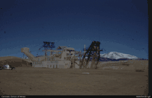
 View of Fairplay and South Park looking south from State Highway 9. The historic buildings of South Park City, an open-air museum, are in the foreground. | |
| Nicknames: The Real South Park South Park City | |
| Motto: "Where History Meets the High Country" | |
 Location of the Town of Fairplay in Park County, Colorado. | |
 Fairplay Location of the Town of Fairplay in the United States. | |
| Coordinates: 39°13′28″N 105°59′53″W | |
| Country | |
| State | |
| County | Park County seat[1] |
| Settled | 1859 |
| Incorporated | November 15, 1872[2] |
| Government | |
| • Type | Statutory Town[1] |
| • Mayor | Frank Just[3] |
| Area | |
| • Total | 1.156 sq mi (2.995 km2) |
| • Land | 1.147 sq mi (2.971 km2) |
| • Water | 0.009 sq mi (0.024 km2) |
| Elevation | 9,953 ft (3,034 m) |
| Population | |
| • Total | 724 |
| • Density | 631/sq mi (244/km2) |
| • Metro | 2,963,821 (19th) |
| • CSA | 3,623,560 (17th) |
| • Front Range | 5,055,344 |
| Time zone | UTC−07:00 (MST) |
| • Summer (DST) | UTC−06:00 (MDT) |
| ZIP code[6] | 80440 & 80456, 80432 (PO Box) |
| Area code | 719 |
| FIPS code | 08-25610 |
| GNIS feature ID | 0169534 |
| Website | fairplayco.us |
History
A historic gold mining settlement, the town was founded in 1859 during the early days of the Pike's Peak Gold Rush.[8][9] The town was named by settlers who were upset by the generous mining claims given to the earliest prospectors and promised a more equitable system for its residents.[10][11] The town of Fairplay was incorporated in 1872.[12]

It is the largest community in the grassland basin of Colorado known as South Park, sitting on the west edge of the basin at the junction of U.S. Highway 285 and State Highway 9. It is on a hillside just east of the Middle Fork South Platte River, near where Highway 9 ascends the river valley northward to Alma and Hoosier Pass. It is a quiet town, and the roads surrounding it have a low volume of traffic. Although it was founded during the initial placer mining boom, the mines in the area continued to produce gold and silver ore for many decades up through the middle of the 20th century.
The town consists of modern retail businesses along the highway, as well as a historic town on the bluff above the river along Front Street. The northern extension of Front Street along the river has been preserved and has become the site of relocated historic structures as an open-air museum called South Park City, intended to recreate the early days of the Colorado Gold Rush. Most of the residences in town are located on the hillside west of US Highway 285 and east of State Highway 9, in the vicinity of the schools and Park County Courthouse. The majority of the streets in town were finally paved in 2005.

The Town of Fairplay is the visual basis for the Town of South Park in the television series South Park.[13] The people in the show are influenced by Boulder, Colorado, where creators Matt Stone and Trey Parker attended college at the University of Colorado.
Geography
As of the 2020 United States Census, the town had a total area of 740 acres (2.995 km2) including 5.9 acres (0.024 km2) of water.[4]
Climate
Fairplay has a subarctic or subalpine climate (Koppen: Dfc) given its elevation, with short cool summers, and long, windy, cold winters. Temperature ranges between day and night are large, due to the high elevation, low cloud cover, and dryness of the air.
| Climate data for Fairplay, Colorado | |||||||||||||
|---|---|---|---|---|---|---|---|---|---|---|---|---|---|
| Month | Jan | Feb | Mar | Apr | May | Jun | Jul | Aug | Sep | Oct | Nov | Dec | Year |
| Record high °F (°C) | 56 (13) |
54 (12) |
61 (16) |
65 (18) |
80 (27) |
82 (28) |
85 (29) |
83 (28) |
80 (27) |
72 (22) |
66 (19) |
56 (13) |
85 (29) |
| Average high °F (°C) | 31 (−1) |
34 (1) |
38 (3) |
45 (7) |
55 (13) |
67 (19) |
71 (22) |
69 (21) |
62 (17) |
51 (11) |
38 (3) |
31 (−1) |
49 (9) |
| Average low °F (°C) | 3 (−16) |
5 (−15) |
11 (−12) |
19 (−7) |
28 (−2) |
34 (1) |
38 (3) |
38 (3) |
32 (0) |
23 (−5) |
12 (−11) |
4 (−16) |
21 (−6) |
| Record low °F (°C) | −27 (−33) |
−38 (−39) |
−30 (−34) |
−17 (−27) |
7 (−14) |
19 (−7) |
26 (−3) |
23 (−5) |
8 (−13) |
−7 (−22) |
−24 (−31) |
−31 (−35) |
−38 (−39) |
| Average precipitation inches (mm) | 0.64 (16) |
0.79 (20) |
0.94 (24) |
1.08 (27) |
0.63 (16) |
0.80 (20) |
1.78 (45) |
1.76 (45) |
0.90 (23) |
0.74 (19) |
0.80 (20) |
0.72 (18) |
11.58 (293) |
| Average snowfall inches (cm) | 7.9 (20) |
9.4 (24) |
18.3 (46) |
16.4 (42) |
3.7 (9.4) |
0.1 (0.25) |
0 (0) |
0 (0) |
1.7 (4.3) |
7.1 (18) |
11.3 (29) |
10 (25) |
85.9 (217.95) |
| Source: [14] | |||||||||||||
Demographics
| Census | Pop. | Note | %± |
|---|---|---|---|
| 1890 | 301 | — | |
| 1900 | 319 | 6.0% | |
| 1910 | 265 | −16.9% | |
| 1920 | 183 | −30.9% | |
| 1930 | 221 | 20.8% | |
| 1940 | 739 | 234.4% | |
| 1950 | 476 | −35.6% | |
| 1960 | 404 | −15.1% | |
| 1970 | 419 | 3.7% | |
| 1980 | 421 | 0.5% | |
| 1990 | 387 | −8.1% | |
| 2000 | 610 | 57.6% | |
| 2010 | 679 | 11.3% | |
| 2020 | 724 | 6.6% | |
| U.S. Decennial Census | |||
As of the census[15] of 2000, there were 610 people, 259 households, and 169 families residing in the town. The population density was 576 inhabitants per square mile (222/km2). There were 337 housing units at an average density of 318 per square mile (123/km2). The racial makeup of the town was 93% White, 1.3% African American, 1.0% Native American, 0.3% Asian, 2.8% from other races, and 1.5% from two or more races. Hispanic or Latino of any race were 4.9% of the population.
There were 259 households, out of which 32% had children under the age of 18 living with them, 51% were married couples living together, 8% had a female householder with no husband present, and 34% were non-families. 26% of all households were made up of individuals, and 3.9% had someone living alone who was 65 years of age or older. The average household size was 2.36 and the average family size was 2.8.
Approximately 24% of the town under the age of 18, 8% from 18 to 24, 37% from 25 to 44, 25% from 45 to 64, and 5% 65 years of age or older. The median age was 35 years. For every 100 females, there were 110 males. For every 100 females age 18 and over, there were 112 males.
The median income for a household in the town was $50,385, and the median income for a family was $51,980. Males had a median income of $34,290 versus $26,430 for females. The per capita income for the town was $21,740. About 6.6% of families and 9.5% of the population were below the poverty line, including 10.4% of those under age 18 and 5.4% of those age 65 or over.
Arts and culture
Burro Days
The Burro Days festival is held on the last weekend of July.[16] The event celebrates the town's mining heritage. The main feature of the festival is a 29-mile (46.7 km) burro race over rough terrain and approximately 3,000-ft (914 m) elevation gain from downtown Fairplay to the 13,185-ft (4019 m) summit of Mosquito Pass. Teams consist of one person and one burro. The race takes about five hours to complete; first prize is $1,000. Previously, the first prize included an ounce of gold. There are several other burro races in Colorado; the most notable takes place in Leadville.
The Fairplay event is the World Championship of Burro Racing, an ultra-marathon and the longest burro race in the state.[17] For many years (in the 1960s and early 1970s) the Burro race took place from Leadville to Fairplay, or vice versa, crossing over Mosquito Pass. This followed the route that Father John Lewis Dyer of the Methodist Episcopal Church used for circuit riding and for carrying mail. With time, the rivalry between the two cities ended this cooperative endeavor.
Infrastructure
Notable people
- John J. Hoover, convicted murderer lynched by a mob in Fairplay in 1880.
- Sheldon Jackson, Presbyterian missionary who established what is now the South Park Community Presbyterian Church in Fairplay.
In popular culture
The town has become mildly famous in recent years as the town depicted in the South Park animated television series on Comedy Central. Although the geographical references contained in several episodes imply that Fairplay is the model for South Park, it is much smaller and more rustic than its fictional counterpart, which has a more suburban character. Co-creator Trey Parker grew up in Conifer and went to high school in Evergreen, both of which are somewhat more affluent mountain communities immediately west of Denver in Jefferson County. Co-creator Matt Stone lived in the Denver suburb of Littleton.
Because the town is a regional center of government and commerce, the term "South Park" has historically been used in the town in the naming of institutions and business, including South Park High School (the namesake of which appears in the series). The elementary school is Edith Teter Elementary and the middle school is South Park Middle School.
Although the town of South Park is based upon the real life town of Fairplay, the latter is mentioned by Gerald Broflovski in the episode "Night of the Living Homeless" and described as "4 miles away" in "Jakovasaurs", which implies that it is a separate town in the show. The county seat offices in Fairplay are seen, though not mentioned by name, in the episode "Stanley's Cup". In "T.M.I." the Pissed Off and Angry Party invade a FedEx Office location which the news reporter reports as the Fairplay FedEx.
A South Park parallel to the Burro race can be found in the "Cow Days" episode.

See also
References
- "Active Colorado Municipalities". Colorado Department of Local Affairs. Retrieved October 18, 2021.
- "Colorado Municipal Incorporations". State of Colorado, Department of Personnel & Administration, Colorado State Archives. 2004-12-01. Retrieved 2007-09-02.
- "Mayor and Board of Trustees". Town of Fairplay, Colorado. Retrieved June 10, 2014.
- "Decennial Census P.L. 94-171 Redistricting Data". United States Census Bureau, United States Department of Commerce. August 12, 2021. Retrieved September 10, 2021.
- "Colorado Highways: Elevation-Related Trivia Items". Matthew E. Salek. Retrieved 2007-09-14.
- "ZIP Code Lookup". United States Postal Service. Archived from the original (JavaScript/HTML) on November 4, 2010. Retrieved September 14, 2007.
- "Find a County". National Association of Counties. Archived from the original on 2011-05-31. Retrieved 2011-06-07.
- "The Real South Park Colorado". Colorado.com. Retrieved 2022-10-18.
- Noel, Thomas (2022-08-24). "Fairplay". coloradoencyclopedia.org. Retrieved 2022-10-18.
- Fossett, Frank (1880). Colorado, its gold and silver mines: farms and stock ranges, and health and pleasure resorts : tourist's guide to the Rocky Mountains. C.G. Crawford, printer and stationer. p. 123. ISBN 9780405049736.
- Gannett, Henry (1905). The Origin of Certain Place Names in the United States. Govt. Print. Off. pp. 123.
- "Fairplay, Colorado". City-Data.com. Retrieved July 12, 2012.
- "FAQ - South Park Studios". South Park Studios. Retrieved 2010-04-06.
- "Intellicast | Weather Underground".
- "U.S. Census website". United States Census Bureau. Retrieved 2008-01-31.
- "Burro Days". Retrieved 2 June 2011.
- "Western Pack Burro Ass-ociation". Retrieved 2 June 2011.
- "Bustang Schedule". RideBustang. CDOT.
External links
Municipalities and communities of Park County, Colorado, United States | ||
|---|---|---|
| Towns |  Map of Colorado highlighting Park County | |
| CDPs | ||
| Unincorporated communities | ||
| Ghost towns | ||