Fifth Avenue–59th Street station
The Fifth Avenue–59th Street station is a station on the BMT Broadway Line of the New York City Subway. Located under Grand Army Plaza near the intersection of 5th Avenue and 60th Street in Manhattan, it is served by the N train at all times, the W train on weekdays, and the R train at all times except late nights.
5 Avenue–59 Street | ||||||||||||||||||||||||||||||||||||||||||||||||||||||||||||||||||||
|---|---|---|---|---|---|---|---|---|---|---|---|---|---|---|---|---|---|---|---|---|---|---|---|---|---|---|---|---|---|---|---|---|---|---|---|---|---|---|---|---|---|---|---|---|---|---|---|---|---|---|---|---|---|---|---|---|---|---|---|---|---|---|---|---|---|---|---|---|
 Platform view | ||||||||||||||||||||||||||||||||||||||||||||||||||||||||||||||||||||
| Station statistics | ||||||||||||||||||||||||||||||||||||||||||||||||||||||||||||||||||||
| Address | East 60th Street & Fifth Avenue New York, NY 10023 | |||||||||||||||||||||||||||||||||||||||||||||||||||||||||||||||||||
| Borough | Manhattan | |||||||||||||||||||||||||||||||||||||||||||||||||||||||||||||||||||
| Locale | Midtown Manhattan, Upper East Side | |||||||||||||||||||||||||||||||||||||||||||||||||||||||||||||||||||
| Coordinates | 40.764779°N 73.972621°W | |||||||||||||||||||||||||||||||||||||||||||||||||||||||||||||||||||
| Division | B (BMT)[1] | |||||||||||||||||||||||||||||||||||||||||||||||||||||||||||||||||||
| Line | BMT Broadway Line | |||||||||||||||||||||||||||||||||||||||||||||||||||||||||||||||||||
| Services | N R W | |||||||||||||||||||||||||||||||||||||||||||||||||||||||||||||||||||
| Transit | ||||||||||||||||||||||||||||||||||||||||||||||||||||||||||||||||||||
| Structure | Underground | |||||||||||||||||||||||||||||||||||||||||||||||||||||||||||||||||||
| Platforms | 2 side platforms | |||||||||||||||||||||||||||||||||||||||||||||||||||||||||||||||||||
| Tracks | 2 | |||||||||||||||||||||||||||||||||||||||||||||||||||||||||||||||||||
| Other information | ||||||||||||||||||||||||||||||||||||||||||||||||||||||||||||||||||||
| Opened | September 1, 1919[2] | |||||||||||||||||||||||||||||||||||||||||||||||||||||||||||||||||||
| Opposite- direction transfer | Yes | |||||||||||||||||||||||||||||||||||||||||||||||||||||||||||||||||||
| Traffic | ||||||||||||||||||||||||||||||||||||||||||||||||||||||||||||||||||||
| 2019 | 4,995,128[3] | |||||||||||||||||||||||||||||||||||||||||||||||||||||||||||||||||||
| Rank | 93 out of 424[3] | |||||||||||||||||||||||||||||||||||||||||||||||||||||||||||||||||||
| ||||||||||||||||||||||||||||||||||||||||||||||||||||||||||||||||||||
| ||||||||||||||||||||||||||||||||||||||||||||||||||||||||||||||||||||
| ||||||||||||||||||||||||||||||||||||||||||||||||||||||||||||||||||||
| ||||||||||||||||||||||||||||||||||||||||||||||||||||||||||||||||||||
| ||||||||||||||||||||||||||||||||||||||||||||||||||||||||||||||||||||


History
The New York Public Service Commission adopted plans for what was known as the Broadway–Lexington Avenue route on December 31, 1907. This route began at the Battery and ran under Greenwich Street, Vesey Street, Broadway to Ninth Street, private property to Irving Place, and Irving Place and Lexington Avenue to the Harlem River. After crossing under the Harlem River into the Bronx, the route split at Park Avenue and 138th Street, with one branch continuing north to and along Jerome Avenue to Woodlawn Cemetery, and the other heading east and northeast along 138th Street, Southern Boulevard, and Westchester Avenue to Pelham Bay Park. In early 1908, the Tri-borough plan was formed, combining this route, the under-construction Centre Street Loop Subway in Manhattan and Fourth Avenue Subway in Brooklyn, a Canal Street subway from the Fourth Avenue Subway via the Manhattan Bridge to the Hudson River, and several other lines in Brooklyn.[4][5]
The Brooklyn Rapid Transit Company submitted a proposal to the Commission, dated March 2, 1911, to operate the Tri-borough system (but under Church Street instead of Greenwich Street), as well as a branch along Broadway, Seventh Avenue, and 59th Street from Ninth Street north and east to the Queensboro Bridge; the Canal Street subway was to merge with the Broadway Line instead of continuing to the Hudson River. The city, the BRT, and the Interborough Rapid Transit Company (which operated the first subway and four elevated lines in Manhattan) came to an agreement, and sent a report to the New York City Board of Estimate on June 5, 1911. The line along Broadway to 59th Street was assigned to the BRT, while the IRT obtained the Lexington Avenue line, connecting with its existing route at Grand Central–42nd Street. Construction began on Lexington Avenue on July 31, and on Broadway the next year. The Dual Contracts, two operating contracts between the city and the BMT and IRT, were adopted on March 4, 1913.[6]
This station opened on September 1, 1919 as part of an extension of the Broadway Line from 57th Street–Seventh Avenue station to Lexington Avenue/59th Street.[2]
The station was operated by the BMT until the city government took over the BMT's operations on June 1, 1940.[7][8] This station was overhauled in the late 1970s. The MTA fixed the station's structure and overall appearance, replacing the original wall tiles, old signs, and incandescent lighting with 1970s modern-look wall tile band and tablet mosaics, signs and fluorescent lights. It also fixed staircases and platform edges.
In 2002, the station received a major overhaul. It received state-of-art repairs as well as an upgrade of the station for ADA compliance and restoration the original late 1910s tiling. The MTA repaired the staircases, re-tiling for the walls, installed new tiling on the floors, upgraded the station's lights and the public address system, and installed ADA yellow safety threads along the platform edges, new signs, and new track-beds in both directions.
Station layout
| G | Street level | Exit/entrance |
| M | Mezzanine | Fare control, station agent, MetroCard machines |
| P Platform level |
Side platform, doors will open on the right | |
| Southbound | ← ← ← | |
| Northbound | | |
| Side platform, doors will open on the right | ||
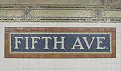

This underground station has two tracks and two side platforms, with a mezzanine above both the western and eastern ends of the station. Replicas of BMT directional mosaics “QUEENS TRAINS” and “BROOKLYN TRAINS” are found on the western exit. Each mezzanine has one stair to each platform. Mosaics “5”, “Fifth Ave,” and the directional signs on each platform, are fully preserved with new tiles encircling around them.
Artwork here was made in 1997 by Ann Schaumburger and is called Urban Oasis. It uses glass mosaic murals to depict families of different types of animals, particularly for the nearby Central Park Zoo.
Exits
The full-time side of the station at the north end, at 60th Street and Fifth Avenue, has three street staircases, one carved into the outer perimeter of Central Park (northwestern corner of that intersection) and the other two on either eastern corner of the intersection.[9] The part-time side at Central Park South, just by the Plaza Hotel, formerly had a booth (closed in 2003) and three street staircases as well: two carved inside Central Park's perimeter, on the northern side of Central Park South, and one to the southern side, inside a building just west of the Plaza Hotel.[9]
References
- "Glossary". Second Avenue Subway Supplemental Draft Environmental Impact Statement (SDEIS) (PDF). Vol. 1. Metropolitan Transportation Authority. March 4, 2003. pp. 1–2. Archived from the original (PDF) on February 26, 2021. Retrieved January 1, 2021.
- "Subway To Open Two New Stations; Broadway Line of B.R.T. Will Extend to Lexington Av. and 60th St. Tomorrow. An Entrance at Fifth Av. Central Manhattan to Have Direct Service to All Brooklyn and Coney Island. Express to Times Square. Tunnel to Queens tow Under Way and Expected to be in Use in Six Months". The New York Times. August 31, 1919. ISSN 0362-4331. Archived from the original on June 14, 2018. Retrieved May 31, 2019.
- "Facts and Figures: Annual Subway Ridership 2014–2019". Metropolitan Transportation Authority. 2020. Retrieved May 26, 2020.
- James Blaine Walker, Fifty Years of Rapid Transit, 1864–1917 Archived June 10, 2019, at the Wayback Machine, published 1918, pp. 207-223
- Engineering News, A New Subway Line for New York City Archived July 5, 2012, at the Wayback Machine, Volume 63, No. 10, March 10, 1910
- James Blaine Walker, Fifty Years of Rapid Transit, 1864–1917 Archived June 10, 2019, at the Wayback Machine, published 1918, pp. 224-241
- "B.M.T. Lines Pass to City Ownership; $175,000,000 Deal Completed at City Hall Ceremony-- Mayor 'Motorman No. 1'". The New York Times. June 2, 1940. ISSN 0362-4331. Archived from the original on July 19, 2021. Retrieved May 14, 2022.
- "City Takes Over B. M. T. System; Mayor Skippers Midnight Train". New York Herald Tribune. June 2, 1940. p. 1. ProQuest 1243059209.
- "MTA Neighborhood Maps: Midtown" (PDF). mta.info. Metropolitan Transit Authority. 2015. Retrieved July 28, 2016.
External links
 Media related to Fifth Avenue (BMT Broadway Line) at Wikimedia Commons
- nycsubway.org – BMT Broadway Subway: Fifth Avenue
- Station Reporter — N Train
- Station Reporter — R Train
- MTA's Arts For Transit — 5th Avenue–59th Street (BMT Broadway Line)
- Fifth Avenue and 60th Street entrance from Google Maps Street View
- Central Park South entrance from Google Maps Street View
- Central Park South lobby from Google Maps Street View
- Platforms from Google Maps Street View