Forest Park Parkway (St. Louis)
Forest Park Parkway is a parkway in St. Louis and Clayton, Missouri that runs from Interstate 170, becomes Forest Park Avenue at Kingshighway Boulevard, and ends at Market Street and Interstate 64. It is considered an arterial snow route.[2][3]
| Forest Park Avenue | |
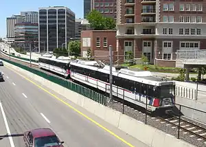
 Forest Park Parkway as seen from the Washington University overpass looking east. | |
| Namesake | Forest Park |
|---|---|
| Type | Parkway |
| Maintained by | St. Louis County, St. Louis |
| Length | 6.8 mi (10.9 km) |
| Location | Clayton–St. Louis, Missouri |
| Postal code | 63105, 63130, 63112, 63108, 63110, 63103[1] |
| East end | |
| Major junctions | Brentwood Blvd, S. Hanley Blvd, Forsyth Blvd, Big Bend, Skinker, Clayton Rd, Kingshighway Blvd, DeBalliviere Ave, Lindell / Union Blvd, Vandeventer Ave, S. Grand Blvd, Market Street |
| West end | |
History
The corridor began life in the 19th century as a heavy rail line used by the Wabash and Rock Island railroads.[4] The heavy rail line was replaced with streetcars, and later, the parkway. Before 1959, Forest Park Avenue ran west from Grand Boulevard in Midtown and terminated at the eastern edge of Forest Park, at Kingshighway Boulevard.[4] Construction on the route west of Kingshighway to the suburban community of Clayton began in 1959 in addition to an eastward expansion that extended the route to its present terminus at Market Street and Compton Avenue at I-64.[4]
Present Day

In 1993, MetroLink's initial light rail line opened between East St. Louis, Illinois and St. Louis-Lambert Airport. Roughly 3.2-miles (5.1 km) of this alignment runs in the historic Wabash Railroad right of way along Forest Park Parkway and adjacent to Forest Park Avenue. In 2006, the Cross County extension opened with roughly 3.4-miles (5.5 km) of track running in the Forest Park Parkway corridor between DeBaliviere Avenue to I-170. There are stations at or below intersections with DeBaliviere, Skinker Boulevard, Big Bend Boulevard, Forsyth Boulevard, and Central Avenue before the alignment turns south into the I-170 corridor.
In 2017, the city of St. Louis and BJC Healthcare opened a reconstructed at-grade interchange between Forest Park Avenue and Kingshighway Boulevard. Previously, Forest Park Avenue dipped below-grade and passed beneath Kingshighway as it entered Forest Park.[5] Currently, the intersection with Grand Boulevard still has this underpass feature as motorists enter and exit I-64.
Major intersections
| County | Location | mi | km | Destination / Intersection | Notes |
|---|---|---|---|---|---|
| City of St. Louis | 0.00 | 0.00 | Market Street / I-64 East | Beginning of Forest Park Ave | |
| 0.6 | 0.96 | Vandeventer Ave | |||
| 2.0 | 3.21 | Kingshighway Blvd | Western Terminus of Avenue
Beginning of Parkway | ||
| 2.6 | 4.18 | Lindell / Union Blvd | Eastbound / Westbound Exit
Eastbound only entrance | ||
| 3.2 | 5.14 | DeBaliviere Ave | |||
| 4.1 | 6.59 | Skinker Blvd | |||
| St. Louis County | University City | 4.8 | 7.72 | Big Bend Blvd | |
| 5.2 | 8.36 | Pershing Ave | No access for eastbound Parkway Traffic | ||
| 6.2 | 9.97 | Bemiston Ave | Eastbound Entrance / Westbound Exit
Signed as "Clayton Business District" | ||
| Clayton | 6.3 | 10.13 | Central Ave (Government Center) | Westbound Exit Only | |
| 6.4 | 10.29 | Brentwood Blvd | Eastbound Exit / Westbound Entrance | ||
| 6.8 | 10.94 | I-170 - St. Louis Lambert International Airport, I-64 | Western Terminus | ||
Light rail stations
| Station | Location | Service | Type | Points of interest |
|---|---|---|---|---|
| Forest Park–DeBaliviere |
250 DeBaliviere Avenue | Red Blue | Below-grade | Forest Park, Missouri History Museum, The Muny, St. Louis Art Museum, St. Louis Zoo, Loop Trolley |
| Skinker |
260 North Skinker Boulevard | Blue | Subway | Washington University in St. Louis, Forest Park, Delmar Loop, |
| University City–Big Bend |
7000 Forest Park Parkway | Blue | Subway | Washington University in St. Louis, Fontbonne University, University City, Missouri |
| Forsyth |
7411 Forsyth Boulevard | Blue | Below-grade | Downtown Clayton, Carondelet Plaza |
| Clayton |
275 South Central Avenue | Blue | At-grade | Downtown Clayton, St. Louis County Government Center, Shaw Park |
References
- "St. Louis city - Missouri Zip Code Boundary Map (MO)". www.zipmap.net. Retrieved 2018-09-20.
- "Snow Route Map". stlouis-mo.gov (Arcgis Map). City of St. Louis, Street Department. Retrieved 2018-09-20.
- "Map of City of St. Louis snow routes" (PDF). stlouis-mo.gov. City of St. Louis, Street Department. 2014-02-05. https://www.stlouis-mo.gov/government/departments/street/documents/Snow-Route-Map.cfm. Retrieved 2018-09-20.
- Ihnen, Alex (2015-12-03). "Kingshighway and Forest Park Parkway Set to Become At-Grade Intersection - NextSTL". NextSTL (A blogpost describing a construction project on Forest Park Parkway that also includes a brief history of the parkway.). Retrieved 2018-09-20.
- "City and BJC to Open Forest Park Parkway at Kingshighway". stlouis-mo.gov. 2017-08-31. Retrieved 2022-11-07.