Green Island (Fortune), Newfoundland and Labrador
Green Island (in French: Île verte) is a rocky island near the mouth of Fortune Bay, Newfoundland. It is located about 10 km (6 mi) west of the Burin Peninsula of Newfoundland near Point May, and 10 km (6 mi) east of Saint Pierre Island in the French overseas collectivity of Saint Pierre and Miquelon.[2]

| Location | Green Island (Fortune), Burin Peninsula, Newfoundland and Labrador, Canada |
|---|---|
| Coordinates | 46°52′48″N 56°05′07″W |
| Tower | |
| Constructed | 1908 (first) 1955 (second) |
| Construction | cast iron tower (first) skeletal tower (second and current) |
| Height | 6.7 m (22 ft) |
| Shape | cylindrical tower with balcony and lantern (first) square frustum tower (second and current)[1] |
| Markings | red tower (first) red lantern (current) |
| Operator | Canadian Coast Guard |
| Light | |
| First lit | 1993 (current) |
| Focal height | 45.4 m (149 ft) |
| Range | 15 nmi (28 km; 17 mi) |
| Characteristic | Fl W 10s |
Sovereignty
In Article XIII of the Treaty of Utrecht (1713),[3] France acknowledged British ownership of and sovereignty over Newfoundland and its adjacent islands, of which Green Island is one.
The Saint Pierre and Miquelon islands later on were ceded back to France by the 1763 Treaty of Paris and the British and French signatories of the 1783 Treaty of Versailles made it clear that the mid channel line between Newfoundland and Saint Pierre and Miquelon was to be the boundary line.[4]
Although the territorial location of the island remained legally unclear for a long time because it is nearer to Saint Pierre island than to Newfoundland but at the same time nearer to Newfoundland than to Little Miquelon, it eventually was assumed to be part of Newfoundland after the British lighthouse had been built on it (1908). The 1972 agreement between Canada and France determining the line constituting the limit of the territorial waters of Canada and of the zones submitted to the fishery jurisdiction of France finally confirmed its location on the Canadian side of the boundary line.[5]
The maritime boundary is demarked by
Point (5) The low water mark on the west point of the south-westernmost island of the Little Green Island group. Latitude 46° 51' 36" N., Longitude 56° 05' 58" W. approximately.
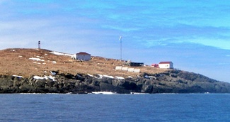
Green Island Lighthouse
The first lighthouse was built on Green Island in 1908. It was replaced in 1955 with an aluminium skeletal tower, and this was replaced with the present structure in 1993. Its light flashes every 10 seconds and is visible for 16 nmi (30 km). The foghorn sounds every 60 seconds as well.
See also
References
- Rowlett, Russ. "Lighthouses of Canada: Southeastern Newfoundland". The Lighthouse Directory. University of North Carolina at Chapel Hill. Retrieved December 30, 2015.
- "St. Pierre et Miquelon: Newfoundland and Labrador Heritage". Archived from the original on 2013-06-02. Retrieved 2006-10-16.
- . 1713 – via Wikisource.
- "The Canadian-French boundary", Xavier Maillard P.M. (University of New Brunswick, Fredericton, 2006)
- "The Canadian-French boundary", Xavier Maillard P.M. (University of New Brunswick, Fredericton, 2006)
Gallery
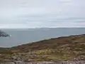 Green Island(s) from Saint Pierre island (France). Iceberg and Newfoundland in background.
 Another shot of Green Island from the north of Saint Pierre island.
External links
- Aids to Navigation Canadian Coast Guard
- Lighthouse website, complete with picture
- Another lighthouse website
- Picture of Green Island Lighthouse