Kharmang District
The Kharmang District (Urdu:ضلع کھرمنگ) is one of the 14 districts of Pakistan-administered territory of Gilgit-Baltistan, bounded on the north by the Skardu District, on the north-east by the Ghanche District, on the south by the Kargil District and the Leh District of [Ladakh,India], and on the west by the Astore District. Its district headquarters is at Tolti.[1] Located in the district is the Kharmang Valley, which is one of the five main valleys in the Baltistan Division.
Kharmang District
ضلع کھرمنگ | |
|---|---|
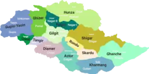 Map of Gilgit-Baltistan showing its 14 districts | |
| Country | |
| Territory | |
| Division | Baltistan Division |
| Headquarters | Tolti |
| Government | |
| • Type | District Administration |
| • Deputy Commissioner | Atiq Shahwani (PAS) |
| • District Police Officer | Ahmed Shabbir (PSP) |
| • District Health Officer | N/A |
| Area | |
| • Total | 7,909 km2 (3,054 sq mi) |
| Population | |
| • Estimate (1998) | 188,000 |
| Number of tehsils | 3 |
Education
According to the Alif Ailaan Pakistan District Education Rankings 2017, Kharmang was ranked 119th out of 155 districts with respect to school infrastructure and facilities.[2]
References
- "کھرمنگ میں موسم سرما کی پہلی برفباری، کئی مقامات پر 5انچ تک برف ریکارڈ کیا گیا". Pamir Times (in Urdu). 11 December 2017. Retrieved 8 February 2021.
- "Pakistan District Education Rankings 2017" (PDF). elections.alifailaan.pk. Archived from the original (PDF) on 30 July 2018. Retrieved 17 August 2019.
Capital: Gilgit | |
| Passes | |
| Valleys | |
| Cities and towns | |
| Rivers, glaciers and lakes |
|
| Architecture | |
| See also | |
This article is issued from Wikipedia. The text is licensed under Creative Commons - Attribution - Sharealike. Additional terms may apply for the media files.