Ladná
Ladná (until 1950 Lanštorf; German: Rampersdorf) is a municipality and village in Břeclav District in the South Moravian Region of the Czech Republic. It has about 1,200 inhabitants.
Ladná | |
|---|---|
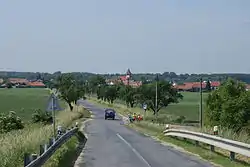 View from the northeast | |
 Flag  Coat of arms | |
 Ladná Location in the Czech Republic | |
| Coordinates: 48°48′20″N 16°52′20″E | |
| Country | |
| Region | South Moravian |
| District | Břeclav |
| First mentioned | 1270 |
| Area | |
| • Total | 10.06 km2 (3.88 sq mi) |
| Elevation | 160 m (520 ft) |
| Population (2022-01-01)[1] | |
| • Total | 1,225 |
| • Density | 120/km2 (320/sq mi) |
| Time zone | UTC+1 (CET) |
| • Summer (DST) | UTC+2 (CEST) |
| Postal code | 691 46 |
| Website | www |
Ladná lies approximately 6 kilometres (4 mi) north of Břeclav, 48 km (30 mi) south-east of Brno, and 228 km (142 mi) south-east of Prague.
Sights

Church of Saint Michael the Archangel
The landmark of Ladná is the Church of Saint Michael the Archangel. It was built in the Neoromanesque style in 1911–1914.[2]
References
- "Population of Municipalities – 1 January 2022". Czech Statistical Office. 2022-04-29.
- "Kostel sv. Archanděla Michaela" (in Czech). Obec Ladná. Retrieved 2022-05-23.
This article is issued from Wikipedia. The text is licensed under Creative Commons - Attribution - Sharealike. Additional terms may apply for the media files.