Luhanske, Bakhmut Raion, Donetsk Oblast
Luhanske (Ukrainian: Луганське; Russian: Луганское, romanized: Luganskoye) is an urban-type settlement in Bakhmut Raion, Donetsk Oblast. Ukraine. It is located on the M04 highway, about 30 kilometres (19 mi) from Bakhmut. The population of Luhanske was 2,140 (2022 est.).[1]
Luhanske
Луганське | |
|---|---|
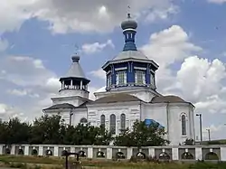 Church of the Intercession (1898) in Luhanske | |
 Luhanske Location of Luhanske within Ukraine  Luhanske Luhanske (Ukraine) | |
| Coordinates: 48°26′29″N 38°15′14″E | |
| Country | |
| Oblast | |
| Raion | Bakhmut |
| Hromada | Svitlodarsk urban hromada |
| Founded | 1701 |
| Incorporated | 1938 |
| Area | |
| • Total | 1.433 km2 (0.553 sq mi) |
| Population (2022) | |
| • Total | 2,140 |
| • Density | 1,500/km2 (3,900/sq mi) |
| Postal code | 84580-84581 |
| Area code | +380 6274 |
The settlement has been damaged by and is on the frontline of the War in Donbass.[2] The UNHCR reported in February 2017 that it was inhabited by a "handful of elderly residents".[2] The settlement was controlled by the Ukrainian army, from 2014 until the 2022 Russian invasion of Ukraine[3] It was captured by Russia in May 2022, and remains under their control.
References
- Чисельність наявного населення України на 1 січня 2022 [Number of Present Population of Ukraine, as of January 1, 2022] (PDF) (in Ukrainian and English). Kyiv: State Statistics Service of Ukraine.
- Elderly bear brunt of hardship in front-line Ukraine village, UNHCR (16 February 2017)
- Ukraine reports 2 WIA's amid 12 enemy attacks in last day, UNIAN (23 November 2017)
| Cities | Coat of arms of Bakhmut Raion | |
|---|---|---|
| Urban-type settlements | ||
| Villages | ||
| Rural settlements | ||
This article is issued from Wikipedia. The text is licensed under Creative Commons - Attribution - Sharealike. Additional terms may apply for the media files.