Lysá hora
Lysá hora (Czech pronunciation: [ˈlɪsaː ˈɦora]; Polish: Łysa Góra; German: Lysa-berg, Kahlberg) is the highest mountain of the Moravian-Silesian Beskids range in the Czech Republic and also of the historical region of Cieszyn Silesia. It is one of the rainiest places of the country with an annual precipitation of over 1,500 mm (60 in). It is the 26th highest mountain in the country.
| Lysá hora | |
|---|---|
 | |
| Highest point | |
| Elevation | 1,323 m (4,341 ft) |
| Prominence | 768 m (2,520 ft) |
| Isolation | 54 km (34 mi) |
| Coordinates | 49°32′45″N 18°26′51″E |
| Geography | |
 Lysá hora Location in the Czech Republic | |
| Location | Krásná, Moravian-Silesian Region, Czech Republic |
| Parent range | Moravian-Silesian Beskids |
| Geology | |
| Mountain type | Godulian Sandstone |
| Climbing | |
| Easiest route | paved road |
Etymology
The name means 'bald mountain'; the name came from the fact that Lysá hora had no trees. The place was first mentioned in a written document from 1261 as Lissa huera.[1]
Climate
| Climate data for Lysá hora (1991−2020 normals, extremes 1980−present) | |||||||||||||
|---|---|---|---|---|---|---|---|---|---|---|---|---|---|
| Month | Jan | Feb | Mar | Apr | May | Jun | Jul | Aug | Sep | Oct | Nov | Dec | Year |
| Record high °C (°F) | 14.5 (58.1) |
12.7 (54.9) |
16.1 (61.0) |
22.8 (73.0) |
26.3 (79.3) |
27.6 (81.7) |
29.0 (84.2) |
29.7 (85.5) |
26.9 (80.4) |
20.7 (69.3) |
13.8 (56.8) |
11.2 (52.2) |
29.7 (85.5) |
| Mean maximum °C (°F) | 5.1 (41.2) |
5.9 (42.6) |
10.1 (50.2) |
16.7 (62.1) |
21.1 (70.0) |
24.4 (75.9) |
25.7 (78.3) |
25.3 (77.5) |
20.0 (68.0) |
16.5 (61.7) |
10.0 (50.0) |
6.3 (43.3) |
26.8 (80.2) |
| Average high °C (°F) | −3.1 (26.4) |
−2.6 (27.3) |
0.5 (32.9) |
6.9 (44.4) |
12.3 (54.1) |
15.7 (60.3) |
17.7 (63.9) |
17.7 (63.9) |
12.1 (53.8) |
7.0 (44.6) |
1.7 (35.1) |
−2.1 (28.2) |
7.0 (44.6) |
| Daily mean °C (°F) | −5.0 (23.0) |
−4.8 (23.4) |
−2.0 (28.4) |
3.6 (38.5) |
8.5 (47.3) |
12.0 (53.6) |
13.9 (57.0) |
14.1 (57.4) |
9.2 (48.6) |
4.6 (40.3) |
−0.1 (31.8) |
−3.9 (25.0) |
4.2 (39.6) |
| Average low °C (°F) | −6.7 (19.9) |
−6.8 (19.8) |
−4.4 (24.1) |
0.5 (32.9) |
5.0 (41.0) |
8.4 (47.1) |
10.3 (50.5) |
10.6 (51.1) |
6.3 (43.3) |
2.3 (36.1) |
−1.7 (28.9) |
−5.6 (21.9) |
1.5 (34.7) |
| Mean minimum °C (°F) | −16.2 (2.8) |
−15.6 (3.9) |
−11.8 (10.8) |
−7.9 (17.8) |
−2.0 (28.4) |
1.9 (35.4) |
4.4 (39.9) |
4.3 (39.7) |
−0.1 (31.8) |
−5.6 (21.9) |
−9.6 (14.7) |
−13.9 (7.0) |
−18.9 (−2.0) |
| Record low °C (°F) | −29.9 (−21.8) |
−25.4 (−13.7) |
−22.8 (−9.0) |
−12.6 (9.3) |
−7.0 (19.4) |
−1.9 (28.6) |
0.2 (32.4) |
−1.0 (30.2) |
−4.9 (23.2) |
−12.0 (10.4) |
−17.8 (0.0) |
−33.0 (−27.4) |
−33.0 (−27.4) |
| Average precipitation mm (inches) | 136.0 (5.35) |
232.5 (9.15) |
127.4 (5.02) |
141.7 (5.58) |
163.9 (6.45) |
178.1 (7.01) |
216.7 (8.53) |
185.8 (7.31) |
180.9 (7.12) |
124.2 (4.89) |
101.8 (4.01) |
99.4 (3.91) |
1,888.5 (74.35) |
| Average precipitation days (≥ 1.0 mm) | 14.3 | 14.2 | 14.1 | 12.9 | 16.0 | 15.5 | 15.8 | 14.0 | 14.3 | 13.9 | 14.4 | 14.9 | 174.3 |
| Source: infoclimat.fr[2] | |||||||||||||
Tourism
Today, the mountain is also a small ski resort and a popular place for hiking in summer, attracting casual hikers, and fans of Nordic walking, running, cross-country skiing, and alpine skiing. It is one of the most visited places in the Beskids. In 2018, roughly 750,000 tourists reached the peak. [3] The area has also hosted various sports competitions.[4][5][6][7]
It is the site of the Ivančena stone mound erected as a memorial for the Scouts who were executed in April 1945 in Cieszyn, modern-day Poland, for their part in anti-Nazi resistance.
Gallery
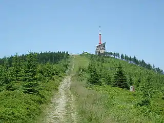 In summer
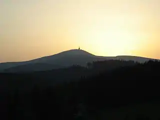 Sunset
 In winter
References
- "Lysá hora – historie". Lysá hora (in Czech). Retrieved 2023-04-05.
- "Normales et records pour la période 1991-2020 à Lysá hora". infoclimat.fr. Retrieved 18 February 2022.
- "Lysá hora v obležení: návštěvnost Beskyd extrémně vzrostla". Euro.cz (in Czech). Retrieved 2023-04-12.
- "Kilpi Beskydská sedmička 2020". Kilpi Beskydská sedmička 2020 (in Czech).
- "adrenalin cup" (in Czech). Archived from the original on 2019-03-28.
- "5 Beskydských vrcholů - Extrémní závod v Beskydech". 5bv.cz (in Czech).
- "Lysacup". lysacup.cz (in Czech).
External links
- lysahora.cz (in Czech)
- Lysá Hora webcam (in Czech)