Millers Ferry, Alabama
Millers Ferry is an unincorporated community in Wilcox County, Alabama, United States.[1] The Millers Ferry Lock and Dam is located near the community on the Alabama River.
Millers Ferry, Alabama | |
|---|---|
 Millers Ferry, Alabama Location within the state of Alabama  Millers Ferry, Alabama Millers Ferry, Alabama (the United States) | |
| Coordinates: 32°5′58.52″N 87°22′2.98″W | |
| Country | United States |
| State | Alabama |
| County | Wilcox |
| Elevation | 131 ft (40 m) |
| Time zone | UTC-6 (Central (CST)) |
| • Summer (DST) | UTC-5 (CDT) |
| Area code | 334 |
2007 tornado
On March 1, 2007, Millers Ferry was struck by a violent EF4 tornado. One person was killed, two others were injured, and over 70 houses were damaged or destroyed. The tornado caused well over $2 million in damage.[2]
Gallery
Below are photographs taken in Millers Ferry as part of the Historic American Buildings Survey:
_ELEVATION_-_Rosemary_House_and_Plantation_Store%252C_State_Route_28_vicinity%252C_Millers_Ferry%252C_HABS_ALA%252C66-MILF.V%252C1-1.tif.jpg.webp) Rosemary House and Plantation
Rosemary House and Plantation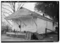 Old store, Rosemary House and Plantation
_ELEVATION_-_Sellers-Henderson_House_and_Smokehouse%252C_State_Route_28%252C_Millers_Ferry%252C_Wilcox_HABS_ALA%252C66-MILF%252C1-1.tif.jpg.webp) Sellers-Henderson House
Sellers-Henderson House
References
- U.S. Geological Survey Geographic Names Information System: Millers Ferry, Alabama
- National Weather Service-March 1 2007, Mills Ferry EF4 Tornado"Alabama Event Report: EF4 Tornado". National Centers for Environmental Information. National Weather Service. Retrieved 7 June 2022.Spann, James (March 2, 2007). "Wilcox County Damage". ABC33/40. Archived from the original on March 13, 2014. Retrieved March 12, 2014."Storm Events Database - Event Details | National Centers for Environmental Information". www.ncdc.noaa.gov. Archived from the original on 2014-03-13. Retrieved 2014-03-13.
Municipalities and communities of Wilcox County, Alabama, United States | ||
|---|---|---|
| City |  Map of Alabama highlighting Wilcox County | |
| Towns | ||
| CDPs | ||
| Unincorporated communities | ||
| Ghost towns | ||
This article is issued from Wikipedia. The text is licensed under Creative Commons - Attribution - Sharealike. Additional terms may apply for the media files.