Phakding
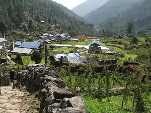
Phakding is a small village in the Khumbu region of Nepal. It lies in the Dudh Kosi river valley just north of Lukla and south of Monjo, at an altitude of 2,610 m,[1][2][3] one of the UNESCO World Heritage Site since 1979.
Phadking | |
|---|---|
 Trail exiting the village of Phakding leading to Lukla. | |
 Phadking Location in Nepal  Phadking Phadking (Nepal) | |
| Coordinates: 27°45′N 86°43′E | |
| Country | |
| Province | Province No. 1 |
| District | Solukhumbu District |
| Rural municipality | Khumbu Pasanglhamu |
| Government | |
| • Type | Ward division |
| Elevation | 2,610 m (8,560 ft) |
| Time zone | UTC+5:45 (Nepal Time) |
| Area code | 038 |
The trail starts at Lukla and Phakding is often the main stopping point for trekkers on their way to Mount Everest via the Gokyo Ri route or Tengboche route.[2]
The primary function of the village is to support the tourism industry and as such consists of a number of guesthouses.[2]
- Phakding


See also
References
- Archived 2011-02-07 at the Wayback Machine Nepal Map Publisher Ltd.& ISBN 978-9937-8062-1-3;
- Bradley, Mayhew; "Trekking in the Nepal Himalaya"; (2009); 9 ed.; p. 94 (map)+ pp 103-104; Lonely Planet; ISBN 9781741041880
- Bezruchka Stephen; "Trekking in the Nepal: a traveller’s guide"; The Mountaineers ed.; Seattle; (2004); page 220; ISBN 0-89886-535-2
This article is issued from Wikipedia. The text is licensed under Creative Commons - Attribution - Sharealike. Additional terms may apply for the media files.