Tamiami, Florida
Tamiami is a census-designated place (CDP) in Miami-Dade County, Florida, United States. The population was 54,212 at the 2020 census.[2]
Tamiami, Florida | |
|---|---|
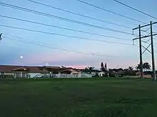
 Tamiami suburb | |
 Location in Miami-Dade County and the state of Florida | |
 U.S. Census Bureau map showing CDP boundaries | |
| Coordinates: 25°45′18″N 80°24′13″W | |
| Country | |
| State | |
| County | Miami-Dade |
| Area | |
| • Total | 7.43 sq mi (19.24 km2) |
| • Land | 7.05 sq mi (18.25 km2) |
| • Water | 0.38 sq mi (0.98 km2) |
| Elevation | 7 ft (2 m) |
| Population | |
| • Total | 54,212 |
| • Density | 7,692.92/sq mi (2,970.18/km2) |
| Time zone | UTC-5 (Eastern (EST)) |
| • Summer (DST) | UTC-4 (EDT) |
| ZIP Codes | 33175, 33182, 33184 (Miami) |
| FIPS code | 12-70700[3] |
| GNIS feature ID | 1867216[4] |
Name
The name Tamiami is a portmanteau of the phrase "Tampa to Miami".[5][6] The Tamiami Trail, a roadway that goes through the Everglades, connecting the two cities, was the reason for this combination.[5][6][7]
Geography
Tamiami is located 14 miles (23 km) west of downtown Miami at 25°45′18″N 80°24′13″W (25.754945, -80.403611).[8] It is bordered to the east by Sweetwater and Westchester, to the southeast by Westwood Lakes, and to the south by Kendale Lakes. U.S. Route 41, the Tamiami Trail, passes through the center of the community, leading east into Miami and west through the Everglades 95 miles (153 km) to Naples. Tampa is an additional 160 miles (260 km) north beyond Naples.

According to the United States Census Bureau, the Tamiami CDP has a total area of 7.4 sq mi (19 km2), of which 0.4 sq mi (1.0 km2), or 5.16%, are water.[1]
Demographics
2020 census
| Race | Number | Percentage |
|---|---|---|
| White (NH) | 3,210 | 5.92% |
| Black or African American (NH) | 191 | 0.35% |
| Native American or Alaska Native (NH) | 8 | 0.01% |
| Asian (NH) | 325 | 0.6% |
| Pacific Islander (NH) | 6 | 0.01% |
| Some Other Race (NH) | 146 | 0.27% |
| Mixed/Multi-Racial (NH) | 247 | 0.46% |
| Hispanic or Latino | 50,079 | 92.38% |
| Total | 54,212 | 100% |
As of the 2020 United States census, there were 54,212 people, 16,057 households, and 13,185 families residing in the CDP.
2010 census
| Tamiami Demographics | |||
|---|---|---|---|
| 2010 Census | Tamiami | Miami-Dade County | Florida |
| Total population | 55,271 | 2,496,435 | 18,801,310 |
| Population, percent change, 2000 to 2010 | +0.9% | +10.8% | +17.6% |
| Population density | 7,819.7/sq mi | 1,315.5/sq mi | 350.6/sq mi |
| White or Caucasian (including White Hispanic) | 94.5% | 73.8% | 75.0% |
| (Non-Hispanic White or Caucasian) | 6.2% | 15.4% | 57.9% |
| Black or African-American | 1.3% | 18.9% | 16.0% |
| Hispanic or Latino (of any race) | 92.7% | 65.0% | 22.5% |
| Asian | 0.7% | 1.5% | 2.4% |
| Native American or Native Alaskan | 0.1% | 0.2% | 0.4% |
| Pacific Islander or Native Hawaiian | 0.0% | 0.0% | 0.1% |
| Two or more races (Multiracial) | 1.3% | 2.4% | 2.5% |
| Some Other Race | 2.1% | 3.2% | 3.6% |
As of 2010, there were 17,256 households, with 3.0% being vacant. As of 2000, 42.1% had children under the age of 18 living with them, 66.0% were married couples living together, 16.2% had a female householder with no husband present, and 12.6% were non-families. 9.4% of all households were made up of individuals, and 3.5% had someone living alone who was 65 years of age or older. The average household size was 3.33 and the average family size was 3.50.
2000 census
As of 2000, the CDP population was spread out, with 24.4% under the age of 18, 8.7% from 18 to 24, 30.0% from 25 to 44, 24.1% from 45 to 64, and 12.9% who were 65 years of age or older. The median age was 37 years. For every 100 females, there were 90.4 males. For every 100 females age 18 and over, there were 85.4 males.
As of 2000, the median income for a household in the CDP was $47,503, and the median income for a family was $49,763. Males had a median income of $30,716 versus $26,426 for females. The per capita income for the CDP was $17,601. About 7.6% of families and 9.4% of the population were below the poverty line, including 12.0% of those under age 18 and 9.7% of those age 65 or over.
As of 2000, speakers of Spanish as a first language accounted for 92.39% of residents, while English was the mother tongue of 6.99% of the population. Other languages spoken were well below 1% of the population.[10]
| Census | Pop. | Note | %± |
|---|---|---|---|
| 1980 | 17,607 | — | |
| 1990 | 33,845 | 92.2% | |
| 2000 | 54,788 | 61.9% | |
| 2010 | 55,271 | 0.9% | |
| 2020 | 54,212 | −1.9% | |
| source:[11] | |||
Education
Miami-Dade County Public Schools operates public schools.[12]
Elementary schools:
- Marjory Stoneman Douglas Elementary School[13]
- Greenglade Elementary School[14]
- Joe Hall Elementary School[15]
- Zora Neale Hurston Elementary School[16]
- Wesley Matthews Elementary School[17]
- Village Green Elementary School[18]
Middle schools:
The Roman Catholic Archdiocese of Miami operates Catholic schools. St. Kevin School is in Tamiami.[12][21]It opened in August 1980.[22] Belen Jesuit Preparatory School is also in Tamiami.[12][23]
References
- "2022 U.S. Gazetteer Files: Florida". United States Census Bureau. Retrieved January 13, 2023.
- "P1. Race – Tamiami CDP, Florida: 2020 DEC Redistricting Data (PL 94-171)". U.S. Census Bureau. Retrieved January 13, 2023.
- "U.S. Census website". United States Census Bureau. Retrieved 2008-01-31.
- "US Board on Geographic Names". United States Geological Survey. 2007-10-25. Retrieved 2008-01-31.
- "Florida Highways – The Tamiami Trail". Marco Island Living. Retrieved November 21, 2020.
- Cirbusova, Mimi (May 10, 2020). "From Tampa to Miami: The Tamiami Trail". compassrosehistory.com. Retrieved November 21, 2020.
- "Tamiami Trail: From Tampa to Miami". myscenicdrives.com. Retrieved November 21, 2020.
- "US Gazetteer files: 2010, 2000, and 1990". United States Census Bureau. 2011-02-12. Retrieved 2011-04-23.
- "Explore Census Data". data.census.gov. Retrieved 2022-02-08.
- "MLA Data Center Results of Tamiami, FL". Modern Language Association. Retrieved 2007-11-10.
- "CENSUS OF POPULATION AND HOUSING (1790-2000)". U.S. Census Bureau. Retrieved 2010-07-17.
- "2010 CENSUS - CENSUS BLOCK MAP: Tamiami CDP, FL" (PDF). U.S. Census Bureau. Retrieved 2020-05-06. - Page 1 and Page 2 - Compare addresses of schools to these maps.
- "Marjory Stoneman Douglas Elementary School". Miami-Dade County Public Schools. Retrieved 2020-05-06.
11901 SW 2 STREET MIAMI, FL 33184
- "Contact Us". Greenglade Elementary School. Retrieved 2020-05-06.
3060 Sw 127th Avenue, Miami, Fl 33175
- "Joe Hall Elementary School". Miami-Dade County Public Schools. Retrieved 2020-05-06.
1901 SW 134TH AVENUE MIAMI, FL 33175
- "Contact". Zora Neale Hurston Elementary School. Retrieved 2020-05-06.
Zora Neale Hurston 13137 SW 26 STREET Miami, FL 33175
- "Contact Us". Wesley Matthews Elementary School. Retrieved 2020-05-06.
12345 SW 18 Terrace Miami, Florida 33175
- "Home". Village Green Elementary School. Retrieved 2020-05-06.
12265 Southwest 34 Street Miami, Florida 33175
- "Contact". Paul W. Bell Middle School. Retrieved 2020-05-06.
11800 NW 2nd St. Miami, FL 33182
- "Contact". W. R. Thomas Middle School. Retrieved 2020-05-06.
13001 SW 26th St. Miami, FL 33175
- "Contact". St. Kevin Catholic School. Retrieved 2020-05-06.
St. Kevin Catholic School 4001 S.W. 127th avenue Miami, Fl 33175
- "About". St. Kevin Catholic School. Retrieved 2020-05-06.
- "Home". Belen Jesuit Preparatory School. Retrieved 2020-05-06.
500 SW 127th Avenue, Miami, FL 33184
- The address states "Miami, FL" but it is actually in the unincorporated Tamiami CDP.
Municipalities and communities of Miami-Dade County, Florida, United States | ||
|---|---|---|
| Cities |  | |
| Towns | ||
| Villages | ||
| CDPs |
| |
| Unincorporated communities | ||
| Ghost town | ||
| Indian reservation | ||
| Footnotes | ‡This populated place also has portions in an adjacent county or counties | |