Yamaguchi (city)
Yamaguchi (山口市, Yamaguchi-shi, literally "the entrance to the mountain") is the capital city of Yamaguchi Prefecture, Japan. The city was founded on April 10, 1929. As of February 1, 2010, the city had an estimated population of 198,971 and a population density of 194.44 persons per km². The total area is 1,023.31 km².
Yamaguchi
山口市 | |
|---|---|
| Yamaguchi City | |
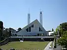
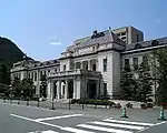
Yamaguchi Xavier Memorial Church Yamaguchi Prefectural Government Museum Rurikō-ji five-story pagoda View of Yamaguchi Yamaguchi Satellite Earth Station | |
 Flag  Emblem | |
Interactive map outlining Yamaguchi | |
 Location of Yamaguchi in Yamaguchi Prefecture | |
 Yamaguchi Location in Japan | |
| Coordinates: 34°11′N 131°28′E | |
| Country | Japan |
| Region | Chūgoku (San'yō) |
| Prefecture | Yamaguchi Prefecture |
| Government | |
| • Mayor | Sumitada Watanabe |
| Area | |
| • Total | 1,023.31 km2 (395.10 sq mi) |
| Population (February 1, 2010) | |
| • Total | 198,971 |
| • Density | 194.44/km2 (503.6/sq mi) |
| Time zone | UTC+09:00 (JST) |
| City hall address | 2-1 Kameyama-cho, Yamaguchi-shi, Yamaguchi-ken 753-8650 |
| Climate | Cfa |
| Website | www |
| Symbols | |
| Flower | Rapeseed flowers, Sakura |
| Tree | Ginkgo |


Yamaguchi is home to the Buddhist temple, Rurikō-ji (瑠璃光寺, Rurikō-ji), with its five-story pagoda.
Yamaguchi is served by Yamaguchi Ube Airport in nearby Ube.
History
Merger history
- April 1, 1889: 40 towns were merged to form the town of Yamaguchi.
- April 1, 1905: The village of Kami-unorei was merged into the town of Yamaguchi.
- July 1, 1915: The village of Shimo-unorei was merged into the town of Yamaguchi.
- April 10, 1929: The town of Yamaguchi absorbed the village of Yoshiki to create the city of Yamaguchi (1st Generation).
- April 1, 1941: The village of Miyano was merged into the city of Yamaguchi.
- April 1, 1944: The towns of Ogōri and Ajisu, and the villages of Hirakawa, Ōtoshi, Sue, Natajima, Aiofutajima, Kagawa and Sayama were merged with the city of Yamaguchi (1st Generation) to become the new city of Yamaguchi (2nd Generation). (At that time of the merger, all of them were from Yoshiki District.)
- November 23, 1947: The town of Ajisu was broken off from Yamaguchi.
- November 1, 1949: The town of Ogōri was broken off from Yamaguchi.
- November 3, 1963: The village of Suzenji (from the Yoshiki District) merged into Yamaguchi.
- May 1, 1963: The town of Ōuchi (from Yoshiki District) was merged into Yamaguchi.
- October 1, 2005: Yamaguchi (2nd Generation) merged with town of Tokuji (from Saba District), and the towns of Aio, Ajisu and Ogōri (all from Yoshiki District) to create the 3rd city of Yamaguchi. Yoshiki District was dissolved as a result of this merger.
- January 16, 2010: Yamaguchi absorbed the town of Atō (from Abu District).
Geography
Climate
Yamaguchi has a humid subtropical climate (Köppen climate classification Cfa) with hot summers and cool winters. Precipitation is significant throughout the year, but is much higher in summer than in winter.
| Climate data for Yamaguchi (1991−2020 normals, extremes 1966−present) | |||||||||||||
|---|---|---|---|---|---|---|---|---|---|---|---|---|---|
| Month | Jan | Feb | Mar | Apr | May | Jun | Jul | Aug | Sep | Oct | Nov | Dec | Year |
| Record high °C (°F) | 19.5 (67.1) |
22.5 (72.5) |
24.8 (76.6) |
30.1 (86.2) |
33.8 (92.8) |
34.7 (94.5) |
38.8 (101.8) |
38.6 (101.5) |
35.9 (96.6) |
31.3 (88.3) |
26.4 (79.5) |
23.3 (73.9) |
38.8 (101.8) |
| Average high °C (°F) | 9.4 (48.9) |
11.1 (52.0) |
15.0 (59.0) |
20.1 (68.2) |
24.9 (76.8) |
27.8 (82.0) |
31.3 (88.3) |
32.7 (90.9) |
28.9 (84.0) |
23.7 (74.7) |
17.6 (63.7) |
11.6 (52.9) |
21.2 (70.2) |
| Daily mean °C (°F) | 4.4 (39.9) |
5.5 (41.9) |
9.0 (48.2) |
13.9 (57.0) |
19.0 (66.2) |
22.6 (72.7) |
26.4 (79.5) |
27.4 (81.3) |
23.5 (74.3) |
17.7 (63.9) |
11.9 (53.4) |
6.4 (43.5) |
15.6 (60.1) |
| Average low °C (°F) | 0.4 (32.7) |
0.8 (33.4) |
3.6 (38.5) |
8.1 (46.6) |
13.3 (55.9) |
18.4 (65.1) |
22.7 (72.9) |
23.4 (74.1) |
19.4 (66.9) |
12.9 (55.2) |
7.0 (44.6) |
2.0 (35.6) |
11.0 (51.8) |
| Record low °C (°F) | −7.6 (18.3) |
−8.9 (16.0) |
−7.6 (18.3) |
−1.2 (29.8) |
3.2 (37.8) |
8.0 (46.4) |
13.1 (55.6) |
14.9 (58.8) |
7.4 (45.3) |
1.3 (34.3) |
−2.5 (27.5) |
−5.5 (22.1) |
−8.9 (16.0) |
| Average precipitation mm (inches) | 76.3 (3.00) |
85.0 (3.35) |
145.6 (5.73) |
168.1 (6.62) |
197.2 (7.76) |
282.9 (11.14) |
342.6 (13.49) |
205.8 (8.10) |
179.1 (7.05) |
91.3 (3.59) |
83.5 (3.29) |
70.5 (2.78) |
1,927.7 (75.89) |
| Average snowfall cm (inches) | 11 (4.3) |
9 (3.5) |
2 (0.8) |
0 (0) |
0 (0) |
0 (0) |
0 (0) |
0 (0) |
0 (0) |
0 (0) |
0 (0) |
3 (1.2) |
26 (10) |
| Average precipitation days (≥ 0.5 mm) | 12.2 | 11.5 | 12.4 | 10.6 | 10.1 | 12.8 | 12.3 | 10.7 | 10.2 | 7.5 | 8.9 | 11.4 | 130.7 |
| Average relative humidity (%) | 76 | 71 | 70 | 69 | 67 | 75 | 78 | 75 | 74 | 73 | 76 | 78 | 74 |
| Mean monthly sunshine hours | 117.9 | 121.3 | 157.4 | 183.9 | 204.3 | 142.3 | 156.2 | 196.2 | 151.7 | 169.4 | 144.0 | 117.6 | 1,862 |
| Source: Japan Meteorological Agency[1] | |||||||||||||
| Climate data for Tokusa, Yamaguchi (1991−2020 normals, extremes 1977−present) | |||||||||||||
|---|---|---|---|---|---|---|---|---|---|---|---|---|---|
| Month | Jan | Feb | Mar | Apr | May | Jun | Jul | Aug | Sep | Oct | Nov | Dec | Year |
| Record high °C (°F) | 16.8 (62.2) |
20.1 (68.2) |
22.9 (73.2) |
28.9 (84.0) |
32.2 (90.0) |
32.7 (90.9) |
36.1 (97.0) |
36.4 (97.5) |
35.1 (95.2) |
30.7 (87.3) |
25.0 (77.0) |
21.8 (71.2) |
36.4 (97.5) |
| Average high °C (°F) | 6.4 (43.5) |
7.9 (46.2) |
12.2 (54.0) |
18.1 (64.6) |
23.0 (73.4) |
25.7 (78.3) |
29.1 (84.4) |
30.4 (86.7) |
26.3 (79.3) |
21.0 (69.8) |
15.2 (59.4) |
9.0 (48.2) |
18.7 (65.6) |
| Daily mean °C (°F) | 1.8 (35.2) |
2.8 (37.0) |
6.3 (43.3) |
11.7 (53.1) |
16.8 (62.2) |
20.5 (68.9) |
24.4 (75.9) |
25.1 (77.2) |
20.9 (69.6) |
14.8 (58.6) |
9.2 (48.6) |
3.9 (39.0) |
13.2 (55.7) |
| Average low °C (°F) | −2.1 (28.2) |
−1.9 (28.6) |
0.8 (33.4) |
5.6 (42.1) |
11.0 (51.8) |
16.3 (61.3) |
20.8 (69.4) |
21.2 (70.2) |
16.7 (62.1) |
9.6 (49.3) |
3.9 (39.0) |
−0.4 (31.3) |
8.5 (47.2) |
| Record low °C (°F) | −12.4 (9.7) |
−16.0 (3.2) |
−9.5 (14.9) |
−4.1 (24.6) |
0.7 (33.3) |
4.6 (40.3) |
12.2 (54.0) |
13.1 (55.6) |
3.9 (39.0) |
−1.5 (29.3) |
−4.4 (24.1) |
−10.4 (13.3) |
−16.0 (3.2) |
| Average precipitation mm (inches) | 121.9 (4.80) |
106.3 (4.19) |
146.7 (5.78) |
136.6 (5.38) |
153.7 (6.05) |
229.5 (9.04) |
337.8 (13.30) |
201.5 (7.93) |
208.6 (8.21) |
116.7 (4.59) |
97.4 (3.83) |
116.3 (4.58) |
1,973 (77.68) |
| Average precipitation days (≥ 1.0 mm) | 15.8 | 13.5 | 13.7 | 11.0 | 10.0 | 12.6 | 13.1 | 10.9 | 11.6 | 9.2 | 10.7 | 14.1 | 146.2 |
| Mean monthly sunshine hours | 66.5 | 86.6 | 133.7 | 172.5 | 193.0 | 127.0 | 136.0 | 171.3 | 129.6 | 150.5 | 112.3 | 74.8 | 1,553.5 |
| Source: Japan Meteorological Agency[2][3] | |||||||||||||
Demographics
Per Japanese census data, the population of Yamaguchi in 2020 is 193,966 people.[4] Yamaguchi has been conducting censuses since 1960.
| Year | Pop. | ±% |
|---|---|---|
| 1960 | 172,116 | — |
| 1965 | 162,219 | −5.8% |
| 1970 | 160,347 | −1.2% |
| 1975 | 164,470 | +2.6% |
| 1980 | 173,590 | +5.5% |
| 1985 | 183,149 | +5.5% |
| 1990 | 187,793 | +2.5% |
| 1995 | 193,172 | +2.9% |
| 2000 | 197,115 | +2.0% |
| 2005 | 199,297 | +1.1% |
| 2010 | 196,643 | −1.3% |
| 2015 | 197,422 | +0.4% |
| 2020 | 193,966 | −1.8% |
| Yamaguchi population statistics[4] | ||
Places of interest
- Rurikō-ji, a five-story pagoda and national treasure
- Yamaguchi Xavier Memorial Church
- Yamaguchi Prefectural Museum of Art
- Ōuchi-shi Yakata - A castle ruin, one of the Continued Top 100 Japanese Castles
- Kōnomine Castle - A castle ruin, one of the Continued Top 100 Japanese Castles.[5]
- Chūya Nakahara Memorial Museum
- Yuda Onsen
Education
Transportation
Railways
Expressways
Twin towns – sister cities
Notes
- 1.^ Kami-Kanakoso, Shimo-Kanakoso, Yawatanobaba, Noda, Kami-Tatekōji, Shimo-Tatekōji, Ishigan-non, Dōso, Enseiji, Dōnomae, Ōichi, Shogan-shōji, Kubo-shōji, Sentō-shōji, Shinbaba, Ushirogawara, Nakagawara, Hayamada, Shin, Komeya, Otsubone-shōji, Ima-shōji, Nakaichi, Aimono-shōji, Tachiuri, Matsunoki, Kitano-shōji, Babadono-shōji, Yonedono-shōji, Dōjōmonzen, Imaichi, Imamichi, Wani-ishi, Ōzuke, Shinbashi, Nishimonzen, Itoyone-shōji, Arataka, Ta and Nakasanai (all from Yoshiki District)
References
- 気象庁 / 平年値(年・月ごとの値). Japan Meteorological Agency. Retrieved May 19, 2021.
- 気象庁 / 平年値(年・月ごとの値). JMA. Retrieved May 26, 2022.
- 観測史上1~10位の値(年間を通じての値). JMA. Retrieved May 26, 2022.
- Yamaguchi population statistics
- "続日本100名城" (in Japanese). 日本城郭協会. 29 November 2017. Retrieved 25 July 2019.
- "国際交流". city.yamaguchi.lg.jp (in Japanese). Yamaguchi. Retrieved 2020-04-08.
External links
 Media related to Yamaguchi, Yamaguchi at Wikimedia Commons
 Geographic data related to Yamaguchi (city) at OpenStreetMap
- Yamaguchi City official website (in Japanese)
| Core city | ||
|---|---|---|
| Cities | ||
| Districts | ||