Bätterkinden
Bätterkinden is a municipality in the administrative district of Emmental in the canton of Berne in Switzerland.
Bätterkinden | |
|---|---|
 Coat of arms | |
Location of Bätterkinden 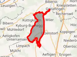 | |
 Bätterkinden Bätterkinden | |
| Coordinates: 47°8′N 7°32′E | |
| Country | Switzerland |
| Canton | Bern |
| District | Emmental |
| Government | |
| • Mayor | Gemeindepräsident Rosmarie Habegger-Scheidegger SVP/UDC (as of 2009) |
| Area | |
| • Total | 10.19 km2 (3.93 sq mi) |
| Elevation | 473 m (1,552 ft) |
| Population (2018-12-31)[2] | |
| • Total | 3,251 |
| • Density | 320/km2 (830/sq mi) |
| Time zone | UTC+01:00 (Central European Time) |
| • Summer (DST) | UTC+02:00 (Central European Summer Time) |
| Postal code(s) | 3315 |
| SFOS number | 0533 |
| Localities | Bätterkinden, Kräiligen, Alp, Holzhäusern, Berchtoldshof, Buuchi, Studenacher, Löffelhof, Neumatt, Niedermatt, Rütti |
| Surrounded by | Aefligen, Fraubrunnen, Limpach, Schalunen, Utzenstorf, Wiler bei Utzenstorf, and Zielebach (Canton of Berne); Aetingen, Biberist, Gerlafingen, Küttigkofen, Kyburg-Buchegg, Lohn-Ammannsegg, and Lüterkofen-Ichertswil (Canton of Solothurn) |
| Website | www SFSO statistics |
It is about 20 km (12 mi) north of Bern.

Church of Bätterkinden
References
- "Arealstatistik Standard - Gemeinden nach 4 Hauptbereichen". Federal Statistical Office. Retrieved 13 January 2019.
- "Ständige Wohnbevölkerung nach Staatsangehörigkeitskategorie Geschlecht und Gemeinde; Provisorische Jahresergebnisse; 2018". Federal Statistical Office. 9 April 2019. Retrieved 11 April 2019.
This article is issued from Wikipedia. The text is licensed under Creative Commons - Attribution - Sharealike. Additional terms may apply for the media files.