Dronne
The Dronne (Occitan: Drona) is a river in southwestern France, right tributary of the Isle river. It flows through the Nouvelle-Aquitaine region.
| Dronne | |
|---|---|
 The Dronne at the rapids near Champs-Romain | |
  | |
| Location | |
| Country | France |
| Physical characteristics | |
| Source | |
| - location | Massif Central |
| - elevation | 510 m (1,670 ft) |
| Mouth | |
| - location | Isle |
| - coordinates | 45°2′15″N 0°8′54″W |
| Length | 201 km (125 mi) |
| Discharge | |
| - average | 25.1 m3/s (890 cu ft/s) |
| Basin features | |
| Progression | Isle→ Dordogne→ Gironde estuary→ Atlantic Ocean |
Its name appears, in an old form, in two communes of the Dordogne departmentː Saint-Méard-de-Drône and Saint-Pardoux-de-Drône. Its modern name appears in three communesː Aubeterre-sur-Dronne, Saint-Méard-de-Drône, Saint-Pardoux-de-Drône.
Geography
The Dronne river has a length of 200.6 km (125 mi),[1] and a drainage basin with an area of approximately 2,798 km2 (1,080 sq mi).
Course
The Dronne starts in the Massif Central, in the commune of Bussière-Galant, Creuse department, Nouvelle-Aquitaine region. It starts in the Parc naturel régional Périgord Limousin at an altitude of about 486 metres (1,594 feet).[2]
It flows to the southwest and, finally, the river flows into at Coutras, in the Gironde department, at an altitude of about 4 metres (13 feet).[3]
The Dronne flows through 5 departments and 52 communes, all in the Nouvelle-Aquitaine region; the main communes areː[1]
- Haute-Vienne : Bussière-Galant
- Dordogne : Saint-Pardoux-la-Rivière, Champagnac-de-Belair, Brantôme, Bourdeilles, Mialet, Tocane-Saint-Apre, Ribérac, Saint-Aulaye, La Roche-Chalais
- Charente : Aubeterre-sur-Dronne
- Charente-Maritime : Saint-Aigulin
- Gironde : Les Églisottes-et-Chalaures, Coutras
Main tributaries
The main tributaries of the Charente river are:[1]
|
Left tributaries:
|
Right tributaries:
|
Gallery
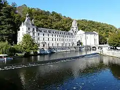 The Dronne and the abbey of Brantôme
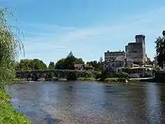 The old bridge over the Dronne, Bourdeilles
 Bridge over the Dronne, Aubeterre-sur-Dronne
.JPG.webp) The Dronne at Coutras
The Dronne at Coutras
Related pages
References
- "La Dronne (P7--0250)" (in French). SANDRE - Portail national d'accès aux référentiels sur l'eau. Retrieved 18 July 2016.
- "Source de la Dronne" (in French). Géoportail. Retrieved 18 July 2016.
- "Confluence de la Dronne" (in French). Géoportail. Retrieved 18 July 2016.
Other websites
- Banque Hydro - Station P8462510 - La Dronne à Coutras Archived 2015-02-19 at the Wayback Machine (in French)