Espinasses
Espinasses is a commune in the Hautes-Alpes department.
Espinasses | |
|---|---|
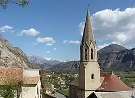 The church and the village of Espinasses | |
 Coat of arms | |
Location of Espinasses  | |
 Espinasses  Espinasses | |
| Coordinates: 44°28′02″N 6°13′32″E | |
| Country | France |
| Region | Provence-Alpes-Côte d'Azur |
| Department | Hautes-Alpes |
| Arrondissement | Gap |
| Canton | Chorges |
| Intercommunality | Pays de Serre Ponçon |
| Government | |
| • Mayor (2008–2014) | Francine Michel |
| Area 1 | 13.86 km2 (5.35 sq mi) |
| Population | 821 |
| • Density | 59/km2 (150/sq mi) |
| Time zone | UTC+01:00 (CET) |
| • Summer (DST) | UTC+02:00 (CEST) |
| INSEE/Postal code | 05050 /05190 |
| Elevation | 637–1,730 m (2,090–5,676 ft) (avg. 652 m or 2,139 ft) |
| 1 French Land Register data, which excludes lakes, ponds, glaciers > 1 km2 (0.386 sq mi or 247 acres) and river estuaries. | |
Population
| Year | Pop. | ±% |
|---|---|---|
| 1962 | 222 | — |
| 1968 | 506 | +127.9% |
| 1975 | 533 | +5.3% |
| 1982 | 565 | +6.0% |
| 1990 | 505 | −10.6% |
| 1999 | 587 | +16.2% |
| 2008 | 660 | +12.4% |
Transport
Road
The D55 and D900B roads pass through the commune.
Location
The commune borders the Alpes-de-Haute-Provence department.
References
- "Populations légales 2019". The National Institute of Statistics and Economic Studies. 29 December 2021.
This article is issued from Wikipedia. The text is licensed under Creative Commons - Attribution - Sharealike. Additional terms may apply for the media files.