Guelma Province
Guelma Province is a province in eastern Algeria. The name is from the largest city Guelma. There are 429.998 people who live here.
Guelma Province
ولاية قالمة | |
|---|---|
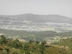 Guelma Valley as seen from Ben Djerrah, partially showing the metropolitan area of Guelma with the cities of Boumahra Ahmed, Belkheir, and Guelma visible (from right to left/east to west) | |
 Map of Algeria highlighting Guelma | |
| Coordinates: 36°28′N 07°27′E | |
| Country | Algeria |
| Capital | Guelma |
| Area | |
| • Total | 4,101 km2 (1,583 sq mi) |
| Population (2008)[1] | |
| • Total | 482,261 |
| • Density | 120/km2 (300/sq mi) |
| Time zone | UTC+01 (CET) |
| Area Code | +213 (0) 37 |
| ISO 3166 code | DZ-24 |
| Districts | 10 |
| Municipalities | 34 |
Divisions
The province has 10 districts and 34 communes or municipalities.[2]
Districts
- Aïn Makhlouf
- Bouchegouf
- Guelaât Bou Sbaâ
- Guelma
- Hammam Debagh
- Hammam N'Bails
- Héliopolis
- Houari Boumédienne
- Khezaras
- Oued Zenati
References
- Office National des Statistiques, Recensement General de la Population et de l’Habitat 2008 Preliminary results of the 2008 population census. Accessed on 2008-07-02.
- Journal Officiel de la République Algérienne, No. 41, Page 1307. 4 September 1991.
This article is issued from Wikipedia. The text is licensed under Creative Commons - Attribution - Sharealike. Additional terms may apply for the media files.