Hauterive, Fribourg
Hauterive is a municipality of the district of Saane in the canton of Fribourg in Switzerland. It was created on 1 January 2001, when the municipalities of Ecuvillens and Posieux joined together to become Hauterive.[3]
Hauterive | |
|---|---|
 View of the southern side of the Abbey of Hauterive at Posieux | |
 Coat of arms | |
Location of Hauterive 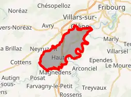 | |
 Hauterive Hauterive | |
| Coordinates: 46°46′N 7°7′E | |
| Country | Switzerland |
| Canton | Fribourg |
| District | Saane |
| Government | |
| • Mayor | Syndic |
| Area | |
| • Total | 11.92 km2 (4.60 sq mi) |
| Elevation | 680 m (2,230 ft) |
| Population (2018-12-31)[2] | |
| • Total | 2,497 |
| • Density | 210/km2 (540/sq mi) |
| Time zone | UTC+01:00 (Central European Time) |
| • Summer (DST) | UTC+02:00 (Central European Summer Time) |
| Postal code(s) | 1725 Posieux 1730 Ecuvillens |
| SFOS number | 2233 |
| Localities | Ecuvillens, Posieux |
| Surrounded by | Arconciel, Corpataux-Magnedens, Cottens, Farvagny, Marly, Matran, Neyruz, Villars-sur-Glâne |
| Website | www SFSO statistics |
The abbey of Hauterive was founded in 1138.
References
- "Arealstatistik Standard - Gemeinden nach 4 Hauptbereichen". Federal Statistical Office. Retrieved 13 January 2019.
- "Ständige Wohnbevölkerung nach Staatsangehörigkeitskategorie Geschlecht und Gemeinde; Provisorische Jahresergebnisse; 2018". Federal Statistical Office. 9 April 2019. Retrieved 11 April 2019.
- Amtliches Gemeindeverzeichnis der Schweiz published by the Swiss Federal Statistical Office (in German) accessed 19 July 2011
Other websites
![]() Media related to Hauterive, Fribourg at Wikimedia Commons
Media related to Hauterive, Fribourg at Wikimedia Commons
- Official website (in French)
- Hauterive Abbey website (in French)
This article is issued from Wikipedia. The text is licensed under Creative Commons - Attribution - Sharealike. Additional terms may apply for the media files.