Kamloops
Kamloops, British Columbia is a city in British Columbia, Canada. It is ranked 37th on the list of 100 largest metropolitan areas in Canada.
City of Kamloops | |
|---|---|
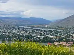 City view of Kamloops | |
| Nickname(s): Tournament Capital of Canada, The Loops | |
| Motto(s): Salus et Opes (Health and Wealth) | |
 City of Kamloops Location of Kamloops in British Columbia | |
| Coordinates: 50°40′34″N 120°20′27″W | |
| Country | Canada |
| Province | British Columbia |
| Regions | Thompson Country |
| District | Thompson-Nicola District |
| Founded | 1811 (fur trading post) |
| Incorporated | 1893 |
| Government | |
| • Type | Elected city council |
| • Mayor | Peter Milobar |
| • Governing body | Kamloops City Council |
| • MP | Cathy McLeod |
| • MLAs | Terry Lake Kevin Krueger |
| Area | |
| • Land | 299.23 km2 (115.53 sq mi) |
| • Metro | 5,668.64 km2 (2,188.67 sq mi) |
| Elevation | 345 m (1,132 ft) |
| Population | |
| • City | 85,678 |
| • Density | 286.3/km2 (742/sq mi) |
| • Metro | 98,754 |
| • Metro density | 17.4/km2 (45/sq mi) |
| Time zone | UTC−8 (PST) |
| • Summer (DST) | UTC−7 (PDT) |
| Postal code span | V2B to V2E |
| Area code(s) | +1-250 & +1-778 |
| GNBC Code | JAFNW[5] |
| NTS Map | 092I09[5] |
| Website | www.kamloops.ca |
At the 2006 census, 86,376 lived in Kamloops.
References
- Kamloops Community Profile - Statistics Canada. 2006 Community Profiles.
- Kamloops, British Columbia (Census agglomeration)
- Elevation at the airport
- Canada Flight Supplement. Effective 0901Z 15 January 2009 to 0901Z 12 March 2009
- Natural Resources Canada Mapping Services
This article is issued from Wikipedia. The text is licensed under Creative Commons - Attribution - Sharealike. Additional terms may apply for the media files.