Kandersteg
Kandersteg is a municipality in the administrative district of Frutigen-Niedersimmental in the canton of Bern in Switzerland. It is along the valley of the river Kander, west of the Jungfrau massif.
Kandersteg | |
|---|---|
 Coat of arms | |
Location of Kandersteg 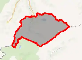 | |
  Kandersteg  Kandersteg | |
| Coordinates: 46°30′N 7°40′E | |
| Country | Switzerland |
| Canton | Bern |
| District | Frutigen-Niedersimmental |
| Government | |
| • Executive | Gemeinderat with 7 members |
| • Mayor | Barbara Jost-Schrepfer |
| Area | |
| • Total | 134.5 km2 (51.9 sq mi) |
| Elevation | 1,174 m (3,852 ft) |
| Highest elevation (Balmhorn) | 3,698 m (12,133 ft) |
| Lowest elevation (Bühl) | 1,150 m (3,770 ft) |
| Population (2018-12-31)[2] | |
| • Total | 1,298 |
| • Density | 9.7/km2 (25/sq mi) |
| Time zone | UTC+01:00 (Central European Time) |
| • Summer (DST) | UTC+02:00 (Central European Summer Time) |
| Postal code(s) | 3718 |
| SFOS number | 0565 |
| Surrounded by | Adelboden, Blatten (Lötschen) (VS), Ferden (VS), Frutigen, Kandergrund, Kippel (VS), Lauterbrunnen, Leukerbad (VS), Reichenbach im Kandertal, Wiler (Lötschen) (VS) |
| Website | www SFSO statistics |
Gallery
 Kandersteg
 Oeschinen Lake
References
- "Arealstatistik Standard - Gemeinden nach 4 Hauptbereichen". Federal Statistical Office. Retrieved 13 January 2019.
- https://www.pxweb.bfs.admin.ch/pxweb/de/; retrieved: 15 June 2020; publisher: Federal Statistical Office.
Other websites
 Media related to Kandersteg at Wikimedia Commons
- Official Website (in German)
- Kandersteg Tourism (in English)
This article is issued from Wikipedia. The text is licensed under Creative Commons - Attribution - Sharealike. Additional terms may apply for the media files.