La Rochepot
La Rochepot is a commune in the Côte-d'Or department and Bourgogne-Franche-Comté region of eastern France.
La Rochepot | |
|---|---|
 A general view of La Rochepot | |
.svg.png.webp) Coat of arms | |
Location of La Rochepot 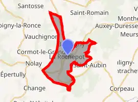 | |
 La Rochepot  La Rochepot | |
| Coordinates: 46°57′32″N 4°40′47″E | |
| Country | France |
| Region | Bourgogne-Franche-Comté |
| Department | Côte-d'Or |
| Arrondissement | Beaune |
| Canton | Arnay-le-Duc |
| Intercommunality | Beaune Côte et Sud |
| Government | |
| • Mayor (2014–2020) | Jérôme Billard |
| Area 1 | 13.91 km2 (5.37 sq mi) |
| Population | 285 |
| • Density | 20/km2 (53/sq mi) |
| Time zone | UTC+01:00 (CET) |
| • Summer (DST) | UTC+02:00 (CEST) |
| INSEE/Postal code | 21527 /21340 |
| Elevation | 324–561 m (1,063–1,841 ft) |
| 1 French Land Register data, which excludes lakes, ponds, glaciers > 1 km2 (0.386 sq mi or 247 acres) and river estuaries. | |
The D973, D906, D33 and D111D roads pass through La Rochepot.
Population
| Year | Pop. | ±% |
|---|---|---|
| 1968 | 275 | — |
| 1975 | 258 | −6.2% |
| 1982 | 272 | +5.4% |
| 1990 | 241 | −11.4% |
| 1999 | 260 | +7.9% |
| 2007 | 281 | +8.1% |
| 2012 | 289 | +2.8% |
| 2017 | 291 | +0.7% |
| Source: INSEE[2] | ||
References
This article is issued from Wikipedia. The text is licensed under Creative Commons - Attribution - Sharealike. Additional terms may apply for the media files.