Lake Maracaibo
| Lake Maracaibo | |
|---|---|
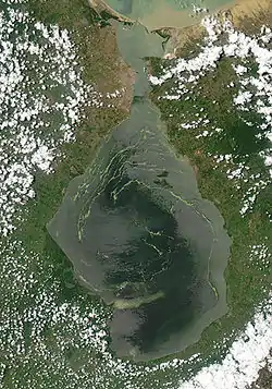 Lake Maracaibo, seen from space. The green swirls in the lake are patches of duckweed, which is infesting the lake. North is at the top of the image. | |
 Map | |
| Coordinates | 09°48′57″N 71°33′24″W |
| Type | Coastal saltwater, bay |
| Primary inflows | Catatumbo River |
| Primary outflows | Gulf of Venezuela |
| Basin countries | Venezuela |
| Max. length | 99 miles (159 km) |
| Max. width | 67 miles (108 km) |
| Surface area | 13,210 km2 (5,100 sq mi) |
| Max. depth | 60 m (200 ft) |
| Water volume | 280 km3 (230,000,000 acre⋅ft) |
| Surface elevation | 0 m (0 ft) |
| Islands | 467 |
| Settlements | Maracaibo, Cabimas, Ciudad Ojeda |
.jpg.webp)
Catacumbo lightning occurs where Catacumbo River empties into Lake Maracaibo
This article is issued from Wikipedia. The text is licensed under Creative Commons - Attribution - Sharealike. Additional terms may apply for the media files.