Le Noyer, Hautes-Alpes
Le Noyer is a commune in the Hautes-Alpes department.
Le Noyer | |
|---|---|
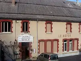 The town hall and former school of Le Noyer | |
 Coat of arms | |
Location of Le Noyer 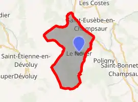 | |
 Le Noyer  Le Noyer | |
| Coordinates: 44°41′57″N 6°00′47″E | |
| Country | France |
| Region | Provence-Alpes-Côte d'Azur |
| Department | Hautes-Alpes |
| Arrondissement | Gap |
| Canton | Saint-Bonnet-en-Champsaur |
| Intercommunality | Champsaur |
| Government | |
| • Mayor (2014–2020) | Renée Nouguier |
| Area 1 | 21.5 km2 (8.3 sq mi) |
| Population | 301 |
| • Density | 14/km2 (36/sq mi) |
| Time zone | UTC+01:00 (CET) |
| • Summer (DST) | UTC+02:00 (CEST) |
| INSEE/Postal code | 05095 /05500 |
| Elevation | 839–2,563 m (2,753–8,409 ft) (avg. 1,120 m or 3,670 ft) |
| 1 French Land Register data, which excludes lakes, ponds, glaciers > 1 km2 (0.386 sq mi or 247 acres) and river estuaries. | |
Population
| Year | Pop. | ±% |
|---|---|---|
| 1962 | 289 | — |
| 1968 | 263 | −9.0% |
| 1975 | 219 | −16.7% |
| 1982 | 215 | −1.8% |
| 1990 | 243 | +13.0% |
| 1999 | 222 | −8.6% |
| 2008 | 257 | +15.8% |
| 2012 | 271 | +5.4% |
Transport
Road
The D17, D17T, D57, D617, D817 and N85 roads pass through the commune.
References
- "Populations légales 2019". The National Institute of Statistics and Economic Studies. 29 December 2021.
This article is issued from Wikipedia. The text is licensed under Creative Commons - Attribution - Sharealike. Additional terms may apply for the media files.