Le Saix
Le Saix is a commune in the Hautes-Alpes department.
Le Saix | |
|---|---|
 The entrance to the village in Le Saix | |
.svg.png.webp) Coat of arms | |
Location of Le Saix 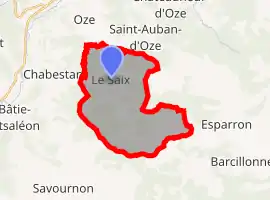 | |
 Le Saix  Le Saix | |
| Coordinates: 44°28′34″N 5°49′28″E | |
| Country | France |
| Region | Provence-Alpes-Côte d'Azur |
| Department | Hautes-Alpes |
| Arrondissement | Gap |
| Canton | Serres |
| Government | |
| • Mayor (2008–2014) | Pierre Schiazza |
| Area 1 | 22.15 km2 (8.55 sq mi) |
| Population | 117 |
| • Density | 5.3/km2 (14/sq mi) |
| Time zone | UTC+01:00 (CET) |
| • Summer (DST) | UTC+02:00 (CEST) |
| INSEE/Postal code | 05158 /05400 |
| Elevation | 774–1,830 m (2,539–6,004 ft) (avg. 813 m or 2,667 ft) |
| 1 French Land Register data, which excludes lakes, ponds, glaciers > 1 km2 (0.386 sq mi or 247 acres) and river estuaries. | |
Population
| Year | Pop. | ±% |
|---|---|---|
| 1962 | 72 | — |
| 1968 | 90 | +25.0% |
| 1975 | 81 | −10.0% |
| 1982 | 77 | −4.9% |
| 1990 | 64 | −16.9% |
| 1999 | 79 | +23.4% |
| 2008 | 92 | +16.5% |
Transport
Road
The D49, D49A and D249T roads pass through the commune.
References
- "Populations légales 2019". The National Institute of Statistics and Economic Studies. 29 December 2021.
This article is issued from Wikipedia. The text is licensed under Creative Commons - Attribution - Sharealike. Additional terms may apply for the media files.