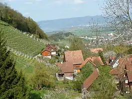
Lutzenberg
Lutzenberg is a municipality of the canton of Appenzell Ausserrhoden in Switzerland.
Lutzenberg | |
|---|---|
 | |
 Coat of arms | |
Location of Lutzenberg 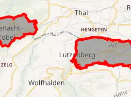 | |
 Lutzenberg Lutzenberg | |
| Coordinates: 47°27′N 9°35′E | |
| Country | Switzerland |
| Canton | Appenzell Ausserrhoden |
| District | n.a. |
| Government | |
| • Mayor | Werner Meier (as of November 2017) |
| Area | |
| • Total | 2.26 km2 (0.87 sq mi) |
| Elevation | 538 m (1,765 ft) |
| Population (2018-12-31)[2] | |
| • Total | 1,279 |
| • Density | 570/km2 (1,500/sq mi) |
| Time zone | UTC+01:00 (Central European Time) |
| • Summer (DST) | UTC+02:00 (Central European Summer Time) |
| Postal code(s) | 9426 |
| SFOS number | 3033 |
| Localities | Brenden, Hof, Haufen, Tobel, Wienacht |
| Surrounded by | Eggersriet (SG), Heiden, Rheineck (SG), Rorschacherberg (SG), St. Margrethen (SG), Thal (SG), Walzenhausen, Wolfhalden |
| Website | www SFSO statistics |
References
- "Arealstatistik Standard - Gemeinden nach 4 Hauptbereichen". Federal Statistical Office. Retrieved 13 January 2019.
- "Ständige Wohnbevölkerung nach Staatsangehörigkeitskategorie Geschlecht und Gemeinde; Provisorische Jahresergebnisse; 2018". Federal Statistical Office. 9 April 2019. Retrieved 11 April 2019.
This article is issued from Wikipedia. The text is licensed under Creative Commons - Attribution - Sharealike. Additional terms may apply for the media files.