Manteyer
Manteyer is a commune in the Hautes-Alpes department.
Manteyer | |
|---|---|
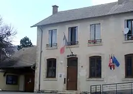 The town hall in Manteyer | |
 Coat of arms | |
Location of Manteyer  | |
 Manteyer  Manteyer | |
| Coordinates: 44°32′19″N 5°57′53″E | |
| Country | France |
| Region | Provence-Alpes-Côte d'Azur |
| Department | Hautes-Alpes |
| Arrondissement | Gap |
| Canton | Veynes |
| Intercommunality | Buëch Dévoluy |
| Government | |
| • Mayor (2020–2026) | Robert Pauchon |
| Area 1 | 25.63 km2 (9.90 sq mi) |
| Population | 427 |
| • Density | 17/km2 (43/sq mi) |
| Time zone | UTC+01:00 (CET) |
| • Summer (DST) | UTC+02:00 (CEST) |
| INSEE/Postal code | 05075 /05400 |
| Elevation | 890–1,974 m (2,920–6,476 ft) (avg. 1,040 m or 3,410 ft) |
| 1 French Land Register data, which excludes lakes, ponds, glaciers > 1 km2 (0.386 sq mi or 247 acres) and river estuaries. | |
Population
| Year | Pop. | ±% |
|---|---|---|
| 1962 | 193 | — |
| 1968 | 200 | +3.6% |
| 1975 | 178 | −11.0% |
| 1982 | 211 | +18.5% |
| 1990 | 222 | +5.2% |
| 1999 | 305 | +37.4% |
| 2008 | 414 | +35.7% |
Transport
Road
The D18, D118 and D118L roads pass through the commune.
References
- "Populations légales 2019". The National Institute of Statistics and Economic Studies. 29 December 2021.
This article is issued from Wikipedia. The text is licensed under Creative Commons - Attribution - Sharealike. Additional terms may apply for the media files.