Ninh Bình province
Ninh Bình (![]() listen) is a province of Vietnam, in the Red River Delta region of the northern part of the country. Ninh Bình has a very short coastline on the Gulf of Tonkin. The population is 898,500 people. Ninh Bình province covers a total area of 1,329.4 square kilometres (513.3 sq mi). The province is known for its limestone caves and grottos (manmade caves).[1] Ninh Binh was the first imperial capital of Vietnam from 968 to 1010 under the Đinh, Lê and Lý dynasties.[1]
listen) is a province of Vietnam, in the Red River Delta region of the northern part of the country. Ninh Bình has a very short coastline on the Gulf of Tonkin. The population is 898,500 people. Ninh Bình province covers a total area of 1,329.4 square kilometres (513.3 sq mi). The province is known for its limestone caves and grottos (manmade caves).[1] Ninh Binh was the first imperial capital of Vietnam from 968 to 1010 under the Đinh, Lê and Lý dynasties.[1]
Ninh Bình province
Tỉnh Ninh Bình | |
|---|---|
.jpg.webp)    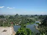    Bích Động valley, near Tam Cốc in Tràng An UNESCO World Heritage Site • Tràng An Scenic Landscape Complex • Phát Diệm Cathedral • Bái Đính Temple • Hoa Lư • Mountain Ngọc Mỹ Nhân • Cave Vân Trình • Cúc Phương National Park | |
| Nickname(s): Serenity | |
 Location of Ninh Bình within Vietnam | |
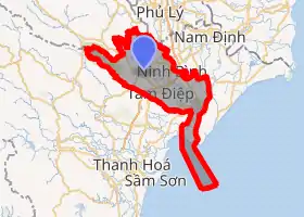 | |
| Coordinates: 20°15′N 105°50′E | |
| Country | |
| Region | Red River Delta |
| Capital | Ninh Bình |
| Government | |
| • People's Council Chair | Đinh Văn Hùng |
| • People's Committee Chair | Đinh Văn Hùng |
| Area | |
| • Total | 1,383.7 km2 (534.2 sq mi) |
| Population (2019) | |
| • Total | 1,119,845 |
| • Density | 810/km2 (2,100/sq mi) |
| Demographics | |
| • Ethnicities | Vietnamese, Mường, Tày, H'Mông |
| Time zone | UTC+07:00 (ICT) |
| Area codes | 229 |
| ISO 3166 code | VN-18 |
| Website | www |
Gallery
 Limestone scenery
 Rice paddies
 Landscape near Ninh Bình
 Tam Cốc-Bích Động
- Phát Diệm Cathedral
.jpg.webp) Hoa Lư - ancient capital
Hoa Lư - ancient capital- Bái Đính Temple
 Khê Hạ village and paddies
References
- "Ninh Binh province – a huge tourism potential". Vietnam Beauty. 2 August 2008. Retrieved 26 January 2016.
Wikimedia Commons has media related to Ninh Binh.
This article is issued from Wikipedia. The text is licensed under Creative Commons - Attribution - Sharealike. Additional terms may apply for the media files.