Schlatt, Zürich
Schlatt bei Winterthur is a municipality of the district of Winterthur in the canton of Zurich in Switzerland.

Oberschlatt

Oberschlatt
Schlatt bei Winterthur | |
|---|---|
 Coat of arms | |
Location of Schlatt bei Winterthur 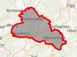 | |
 Schlatt bei Winterthur Schlatt bei Winterthur | |
| Coordinates: 47°28′N 8°50′E | |
| Country | Switzerland |
| Canton | Zurich |
| District | Winterthur |
| Area | |
| • Total | 9.03 km2 (3.49 sq mi) |
| Elevation | 656 m (2,152 ft) |
| Population (2018-12-31)[2] | |
| • Total | 769 |
| • Density | 85/km2 (220/sq mi) |
| Time zone | UTC+01:00 (Central European Time) |
| • Summer (DST) | UTC+02:00 (Central European Summer Time) |
| Postal code(s) | 8418 |
| SFOS number | 0226 |
| Localities | Unterschlatt, Oberschlatt, Waltenstein, Nussberg |
| Surrounded by | Elsau, Hofstetten bei Elgg, Turbenthal, Winterthur, Zell |
| Website | www SFSO statistics |
References
- "Arealstatistik Standard - Gemeinden nach 4 Hauptbereichen". Federal Statistical Office. Retrieved 13 January 2019.
- "Ständige Wohnbevölkerung nach Staatsangehörigkeitskategorie Geschlecht und Gemeinde; Provisorische Jahresergebnisse; 2018". Federal Statistical Office. 9 April 2019. Retrieved 11 April 2019.
Other websites
![]() Media related to Schlatt ZH at Wikimedia Commons
Media related to Schlatt ZH at Wikimedia Commons
- Official website of the municipality of Schlatt (in German)
This article is issued from Wikipedia. The text is licensed under Creative Commons - Attribution - Sharealike. Additional terms may apply for the media files.