Wald, Bern
Wald is a municipality in the administrative district of Bern-Mittelland in the canton of Bern in Switzerland.
Wald | |
|---|---|
 | |
 Coat of arms | |
Location of Wald 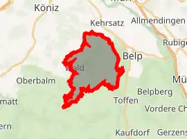 | |
 Wald Wald | |
| Coordinates: 46°53′N 7°28′E | |
| Country | Switzerland |
| Canton | Bern |
| District | Bern-Mittelland |
| Area | |
| • Total | 13.3 km2 (5.1 sq mi) |
| Elevation (Zimmerwald) | 840 m (2,760 ft) |
| Population (2018-12-31)[2] | |
| • Total | 1,177 |
| • Density | 88/km2 (230/sq mi) |
| Time zone | UTC+01:00 (Central European Time) |
| • Summer (DST) | UTC+02:00 (Central European Summer Time) |
| Postal code(s) | 3086 |
| SFOS number | 0888 |
| Localities | Englisberg (with Kühlewil and Unterer Wald), Zimmerwald (with Willishalten, "Bei der Kirche", Niederhäusern, Winzenried, Oberer Wald, Waldhof, Obermuhlern, Egg, Bumishus) |
| Surrounded by | Belp, Kehrsatz, Köniz, Niedermuhlern, Oberbalm, Toffen |
| Website | http://www.wald-be.ch SFSO statistics |
On 1 January 2004, Englisberg and Zimmerwald joined together to become the new municipality, Wald.
Gallery
 Englisberg
 Church of Zimmerwald
References
- "Arealstatistik Standard - Gemeinden nach 4 Hauptbereichen". Federal Statistical Office. Retrieved 13 January 2019.
- "Ständige Wohnbevölkerung nach Staatsangehörigkeitskategorie Geschlecht und Gemeinde; Provisorische Jahresergebnisse; 2018". Federal Statistical Office. 9 April 2019. Retrieved 11 April 2019.
This article is issued from Wikipedia. The text is licensed under Creative Commons - Attribution - Sharealike. Additional terms may apply for the media files.