Walliswil bei Wangen
Walliswil bei Wangen is a municipality of the administrative district Oberaargau of the canton of Bern in Switzerland.
_077.JPG.webp)
Walliswil bei Wangen
Walliswil bei Wangen | |
|---|---|
 Coat of arms | |
Location of Walliswil bei Wangen 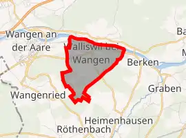 | |
 Walliswil bei Wangen Walliswil bei Wangen | |
| Coordinates: 47°14′N 7°41′E | |
| Country | Switzerland |
| Canton | Bern |
| District | Oberaargau |
| Area | |
| • Total | 3.05 km2 (1.18 sq mi) |
| Elevation | 456 m (1,496 ft) |
| Population (2018-12-31)[2] | |
| • Total | 607 |
| • Density | 200/km2 (520/sq mi) |
| Time zone | UTC+01:00 (Central European Time) |
| • Summer (DST) | UTC+02:00 (Central European Summer Time) |
| Postal code(s) | 3377 |
| SFOS number | 0991 |
| Surrounded by | Berken, Heimenhausen, Röthenbach bei Herzogenbuchsee, Walliswil bei Niederbipp, Wangen an der Aare, Wangenried, Wiedlisbach |
| Website | www SFSO statistics |
References
- "Arealstatistik Standard - Gemeinden nach 4 Hauptbereichen". Federal Statistical Office. Retrieved 13 January 2019.
- "Ständige Wohnbevölkerung nach Staatsangehörigkeitskategorie Geschlecht und Gemeinde; Provisorische Jahresergebnisse; 2018". Federal Statistical Office. 9 April 2019. Retrieved 11 April 2019.
Other websites
![]() Media related to Walliswil bei Wangen at Wikimedia Commons
Media related to Walliswil bei Wangen at Wikimedia Commons
- Official Website (in German)
This article is issued from Wikipedia. The text is licensed under Creative Commons - Attribution - Sharealike. Additional terms may apply for the media files.