Arros (river)
The Arros is a river in southwestern France that flows through the Hautes-Pyrénées and Gers departments, in the Occitanie region. The Arros is a right tributary of the Adour river.
| Arros | |
|---|---|
 The Arros in Saint-Sever-de-Rustan | |
  | |
| Location | |
| Country | France |
| Physical characteristics | |
| Source | |
| - location | Baronnies of Pyrenees |
| Mouth | |
| - location | Adour |
| - coordinates | 43°39′44″N 0°1′41″W |
| Length | 130 km (81 mi) |
| Basin size | 947 km2 (366 sq mi) |
| Discharge | |
| - average | 9 m3/s (320 cu ft/s) |
| Basin features | |
| Progression | Adour→ Atlantic Ocean |
The valleys of the Arros and of the Adour rivers were part of the Comté de Bigorre ("County of Bigorre"). The valley of the Arros was called the Rivière-Haute ("Upper River") and the valley of the Adour was called the Rivière-Basse ("Lower River").
Geography
The Arros river has a length of 130.2 km (80.9 mi),[1] and a drainage basin with an area of approximately 1,283 km2 (495 sq mi).
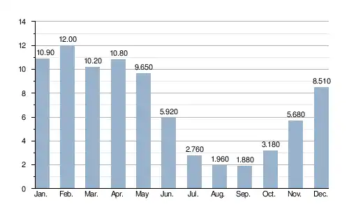
Its average yearly discharge (volume of water which passes through a section of the river per unit of time) is 6.92 m3/s (244 cu ft/s) at Juillac in the Gers department.[2]
 |
Course
The Arros river starts, an altitude of 586 m (1,922.6 ft), in the Forêt des Baronnies, southeast of Bagnères-de-Bigorre, in the Esparros commune.[3] It then flows from south to north through the Hautes-Pyrénées department. It passes through the towns of Bourg-de-Bigorre, Tournay and Chelle-Debat. It gets in the Gers department and passes through the towns of Montégut-Arros and Villecomtal-sur-Arros.
About 4 km (2.5 mi) from Plaisance, the Arros joins, by its right side, the Adour river at an altitude of 113 m (370.7 ft).[4]
The Arros flows through 55 communes and two of them, both in the Gers department, have the name of the river: Montégut-Arros and Villecomtal-sur-Arros.
Main tributaries
Most of the tributaries of the Arros are small streams; the only important tributaries are:
|
Left tributary:
|
|
Right tributary:
|
Gallery
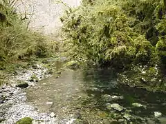 Near the source of the Arros.
 The upper Arros in a very humid valley.
 The Arros in Villecomtal-sur-Arros.
 The Arros in Plaisance.
Related pages
References
- "L'Arros (Q0--0250)" (in French). SANDRE - Portail national d'accès aux référentiels sur l'eau. Retrieved 9 June 2017.
- "L'Arros à Juillac" (in French). Banque Hydro. Archived from the original on 1 October 2018. Retrieved 9 June 2017.
- "Source de l'Arros" (in French). Géoportail. Retrieved 9 June 2017.
- "Confluence de l'Arros" (in French). Géoportail. Retrieved 9 June 2017.