Arvieux
Arvieux is a commune in the Hautes-Alpes department.
Arvieux | |
|---|---|
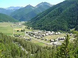 The valley between Brunissard and Arvieux | |
 Coat of arms | |
Location of Arvieux | |
 Arvieux  Arvieux | |
| Coordinates: 44°46′02″N 6°44′23″E | |
| Country | France |
| Region | Provence-Alpes-Côte d'Azur |
| Department | Hautes-Alpes |
| Arrondissement | Briançon |
| Canton | Guillestre |
| Intercommunality | Guillestrois et Queyras |
| Government | |
| • Mayor (2014-2020) | Philippe Chabrand[1] |
| Area 1 | 72.62 km2 (28.04 sq mi) |
| Population | 358 |
| • Density | 4.9/km2 (13/sq mi) |
| Time zone | UTC+01:00 (CET) |
| • Summer (DST) | UTC+02:00 (CEST) |
| INSEE/Postal code | 05007 /05350 |
| Elevation | 1,138–2,905 m (3,734–9,531 ft) (avg. 1,545 m or 5,069 ft) |
| 1 French Land Register data, which excludes lakes, ponds, glaciers > 1 km2 (0.386 sq mi or 247 acres) and river estuaries. | |
Population
| Year | Pop. | ±% |
|---|---|---|
| 2005 | 347 | — |
| 2006 | 348 | +0.3% |
| 2007 | 353 | +1.4% |
| 2008 | 360 | +2.0% |
| 2009 | 368 | +2.2% |
| 2010 | 375 | +1.9% |
| 2011 | 373 | −0.5% |
| 2012 | 371 | −0.5% |
| 2013 | 368 | −0.8% |
| 2014 | 366 | −0.5% |
| 2015 | 363 | −0.8% |
| 2016 | 372 | +2.5% |
Transport
Road

The D902 road passing through the commune
The D802 and D902 roads pass through the commune.
References
- "List of mayors of the Hautes-Alpes department". Prefecture of Hautes-Alpes (in French). 3 June 2014. Archived from the original on 10 January 2015. Retrieved 20 March 2015.
- "Populations légales 2019". The National Institute of Statistics and Economic Studies. 29 December 2021.
This article is issued from Wikipedia. The text is licensed under Creative Commons - Attribution - Sharealike. Additional terms may apply for the media files.