Caraga
Caraga is an administrative region in the Philippines. It is also known as Region XIII. It is on the northeastern part of the island of Mindanao. Butuan is the regional administrative center.
Caraga
Caraga Administrative Region Region XIII | |
|---|---|
    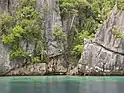  From top, left to right: A naked beach in Siargao Island; Tinuy-an Falls; Rice Corn and Flower Festival in Bayugan; Macapagal Bridge in Butuan; A lagoon in Libjo; Hinatuan Enchanted River | |
 Location in the Philippines | |
| Coordinates: 8°55′N 125°30′E | |
| Country | Philippines |
| Island group | Mindanao |
| Regional center | Butuan |
| Area | |
| • Total | 21,478.35 km2 (8,292.84 sq mi) |
| Population (2020 census)[1] | |
| • Total | 2,804,788 |
| • Density | 130/km2 (340/sq mi) |
| Time zone | UTC+8 (PST) |
| ISO 3166 code | PH-13 |
| Provinces | 5
|
| Cities | 6
|
| Municipalities | 70 |
| Barangays | 1,310 |
| Cong. districts | 7 |
| Languages | |
There are five provinces: Agusan del Norte, Agusan del Sur, Dinagat Islands, Surigao del Norte, and Surigao del Sur.
References
- Census of Population (2015). "Caraga". Total Population by Province, City, Municipality and Barangay. PSA. Retrieved 20 June 2016.
This article is issued from Wikipedia. The text is licensed under Creative Commons - Attribution - Sharealike. Additional terms may apply for the media files.