Casti-Wergenstein
Casti-Wergenstein (Romansh: Casti-Vargistagn) is a municipality in the district of Hinterrhein in the canton of Graubünden.
Casti-Wergenstein | |
|---|---|
 Coat of arms | |
Location of Casti-Wergenstein | |
 Casti-Wergenstein  Casti-Wergenstein | |
| Coordinates: 46°37′N 9°25′E | |
| Country | Switzerland |
| Canton | Graubünden |
| District | Hinterrhein |
| Government | |
| • Mayor | Casper Nicca |
| Area | |
| • Total | 25.62 km2 (9.89 sq mi) |
| Elevation | 1,489 m (4,885 ft) |
| Population (2018-12-31)[2] | |
| • Total | 55 |
| • Density | 2.1/km2 (5.6/sq mi) |
| Time zone | UTC+01:00 (Central European Time) |
| • Summer (DST) | UTC+02:00 (Central European Summer Time) |
| Postal code(s) | 7433 |
| SFOS number | 3703 |
| Localities | Casti, Dumagns, Wergenstein |
| Surrounded by | Andeer, Clugin, Donat, Mathon, Safien, Sufers |
| Website | http://www.casti-vargistagn.ch SFSO statistics |
Villages
- Casti
- Dumagns
- Wergenstein
Gallery
 Casti
Casti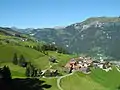 Wergenstein
 Church of Casti
References
- "Arealstatistik Standard - Gemeinden nach 4 Hauptbereichen". Federal Statistical Office. Retrieved 13 January 2019.
- "Bilanz der ständigen Wohnbevölkerung nach institutionellen Gliederungen, Staatsangehörigkeit (Kategorie), Geschlecht und demographischen Komponenten". Federal Statistical Office. Retrieved 12 January 2019.
Other websites
![]() Media related to Casti-Wergenstein at Wikimedia Commons
Media related to Casti-Wergenstein at Wikimedia Commons
- Casti in German, French and Italian in the online Historical Dictionary of Switzerland.
- Wergenstein in German, French and Italian in the online Historical Dictionary of Switzerland.
This article is issued from Wikipedia. The text is licensed under Creative Commons - Attribution - Sharealike. Additional terms may apply for the media files.