Fort Hancock, Texas
Fort Hancock is an unincorporated community and census-designated place (CDP) in Hudspeth County, Texas, United States. Its population was 1,750 at the 2010 census.[3] It is known for being close to the Mexico–United States border.
Fort Hancock, Texas | |
|---|---|
 Abandoned buildings along State Highway 20 in Fort Hancock | |
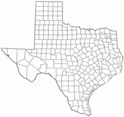 Location of Fort Hancock, Texas | |
 | |
| Coordinates: 31°17′30″N 105°51′37″W | |
| Country | United States |
| State | Texas |
| County | Hudspeth |
| Area | |
| • Total | 19.2 sq mi (49.7 km2) |
| • Land | 19.0 sq mi (49.1 km2) |
| • Water | 0.3 sq mi (0.7 km2) |
| Elevation | 3,579 ft (1,091 m) |
| Population (2010) | |
| • Total | 1,750 |
| • Density | 92/sq mi (35.7/km2) |
| Time zone | UTC-7 (Mountain (MST)) |
| • Summer (DST) | UTC-6 (MDT) |
| ZIP code | 79839 |
| Area code(s) | 915 |
| FIPS code | 48-26724[1] |
| GNIS feature ID | 1357587[2] |
References
- "U.S. Census website". United States Census Bureau. Retrieved 2008-01-31.
- "US Board on Geographic Names". United States Geological Survey. 2007-10-25. Retrieved 2008-01-31.
- "Geographic Identifiers: 2010 Census Summary File 1 (G001): Fort Hancock CDP, Texas". American Factfinder. U.S. Census Bureau. Archived from the original on February 13, 2020. Retrieved March 19, 2018.
This article is issued from Wikipedia. The text is licensed under Creative Commons - Attribution - Sharealike. Additional terms may apply for the media files.