Hofheim, Bavaria
Hofheim in Unterfranken German pronunciation: [ˈhoːfˌhaɪ̯m] (![]() listen)) is a city in Haßberge, Unterfranken, Bavaria in Germany.
listen)) is a city in Haßberge, Unterfranken, Bavaria in Germany.
Hofheim in Unterfranken | |
|---|---|
 Aerial panorama of Hofheim | |
.svg.png.webp) Coat of arms | |
Location of Hofheim in Unterfranken within Haßberge district  | |
 Hofheim in Unterfranken  Hofheim in Unterfranken | |
| Coordinates: 50°8′N 10°11′E | |
| Country | Germany |
| State | Bavaria |
| Admin. region | Unterfranken |
| District | Haßberge |
| Government | |
| • Mayor (2016–22) | Wolfgang Borst[1] (CSU) |
| Area | |
| • Total | 56.35 km2 (21.76 sq mi) |
| Elevation | 250 m (820 ft) |
| Population (2022-12-31)[2] | |
| • Total | 5,116 |
| • Density | 91/km2 (240/sq mi) |
| Time zone | UTC+01:00 (CET) |
| • Summer (DST) | UTC+02:00 (CEST) |
| Postal codes | 97461 |
| Dialling codes | 09523 |
| Vehicle registration | HAS |
| Website | www.stadt-hofheim.de |
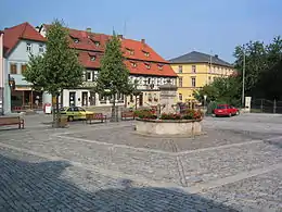
Market square with fountain
The municipality consists of the town of Hofheim and the villages of Eichelsdorf, Erlsdorf, Goßmannsdorf, Lendershausen, Manau, Ostheim, Reckertshausen, Rügheim and Sulzbach.
References
- Liste der ersten Bürgermeister/Oberbürgermeister in kreisangehörigen Gemeinden, Bayerisches Landesamt für Statistik, accessed 19 July 2021.
- Genesis Online-Datenbank des Bayerischen Landesamtes für Statistik Tabelle 12411-003r Fortschreibung des Bevölkerungsstandes: Gemeinden, Stichtag (Einwohnerzahlen auf Grundlage des Zensus 2011) (Hilfe dazu).
Towns and municipalities in Haßberge (district) | ||
|---|---|---|
Coat of Arms of Haßberge district | ||
This article is issued from Wikipedia. The text is licensed under Creative Commons - Attribution - Sharealike. Additional terms may apply for the media files.