Kameyama, Mie
Kameyama (亀山市, Kameyama-shi) is a Japanese city in Mie Prefecture on the island of Honshū.
Kameyama
亀山市 | |
|---|---|
 Kameyama City Hall in Honmaru area | |
 Flag  Seal | |
 Location of Kameyama in Mie Prefecture | |
 Kameyama | |
| Coordinates: 34°51′21″N 136°27′6″E | |
| Country | Japan |
| Region | Kansai |
| Prefecture | Mie Prefecture |
| Government | |
| • -Mayor | Yoshiyuki Sakurai (since February 2009) |
| Area | |
| • Total | 190.91 km2 (73.71 sq mi) |
| Population (November 2012) | |
| • Total | 50,230 |
| • Density | 263/km2 (680/sq mi) |
| Time zone | UTC+9 (Japan Standard Time) |
| - Tree | Cryptomeria |
| - Flower | Japanese iris |
| Phone number | 0595-82-1111 |
| Address | 577 Honmaru-cho, Kameyama-shi, Mie-ken 519-0195 |
| Website | www |
History
In the Edo period, Kameyama-juku, Seki-juku and Sakanoshita-juku were the 46th, 47th and 48th of the 53 shogunate-maintained waystations (shuku-eki) along the Tōkaidō road which connected Edo and Kyoto.[1] All three Tōkaidō rest stops are within the boundaries of modern Numazu.
Gallery

 Seki rest stop by Hiroshige, c. 1830s
 Sakanoshita rest stop by Hiroshige, c. 1830s
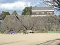 Stone wall at former Kameyama Castle
 Kameyama railway station, early Taishō period (1912–1926)
Related pages
References
- Nussbaum, "Tōkaidō" at p. 973.
Other websites
![]() Media related to Kameyama, Mie at Wikimedia Commons
Media related to Kameyama, Mie at Wikimedia Commons
- Kameyama City website (in Japanese)
- Hiroshige prints, Kameyama Archived 2012-06-11 at the Wayback Machine, Seki Archived 2012-06-11 at the Wayback Machine, Sakanoshita Archived 2012-06-11 at the Wayback Machine
This article is issued from Wikipedia. The text is licensed under Creative Commons - Attribution - Sharealike. Additional terms may apply for the media files.