Lauterbrunnen
Lauterbrunnen is a village and municipality in the administrative district of Interlaken-Oberhasli in the canton of Bern in Switzerland.
Lauterbrunnen | |
|---|---|
 Coat of arms | |
Location of Lauterbrunnen | |
 Lauterbrunnen  Lauterbrunnen | |
| Coordinates: 46°36′N 7°54′E | |
| Country | Switzerland |
| Canton | Bern |
| District | Interlaken-Oberhasli |
| Area | |
| • Total | 164.4 km2 (63.5 sq mi) |
| Elevation (Church) | 802 m (2,631 ft) |
| Population (2018-12-31)[2] | |
| • Total | 2,290 |
| • Density | 14/km2 (36/sq mi) |
| Demonym(s) | German: Lautenbrunner/in |
| Time zone | UTC+01:00 (Central European Time) |
| • Summer (DST) | UTC+02:00 (Central European Summer Time) |
| Postal code(s) | 3822 |
| SFOS number | 0584 |
| Localities | Lauterbrunnen, Wengen, Mürren, Gimmelwald, Stechelberg, Isenfluh, Soustal, Sefinental |
| Surrounded by | Aeschi bei Spiez, Blatten (Lötschen) (VS), Fieschertal (VS), Grindelwald, Gündlischwand, Kandersteg, Lütschental, Reichenbach im Kandertal, Saxeten, Wilderswil |
| Website | www SFSO statistics |
Gallery
 Lauterbrunnen
 Wengen
 Mürren
 Gimmelwald
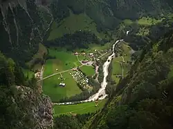 Stechelberg
 Isenfluh
 Jungfraubahn
References
- "Arealstatistik Standard - Gemeinden nach 4 Hauptbereichen". Federal Statistical Office. Retrieved 13 January 2019.
- "Ständige Wohnbevölkerung nach Staatsangehörigkeitskategorie Geschlecht und Gemeinde; Provisorische Jahresergebnisse; 2018". Federal Statistical Office. 9 April 2019. Retrieved 11 April 2019.
Other websites
![]() Media related to Lauterbrunnen at Wikimedia Commons
Media related to Lauterbrunnen at Wikimedia Commons
- Lauterbrunnen in German, French and Italian in the online Historical Dictionary of Switzerland.
- Official Website (in German)
- Truemmbelbachfaelle (in German)
- Moving Postcards Lauterbrunnen Archived 2016-03-05 at the Wayback Machine (in English)
This article is issued from Wikipedia. The text is licensed under Creative Commons - Attribution - Sharealike. Additional terms may apply for the media files.