Mount Suribachi
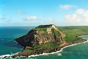
Mount Suribachi (Japanese: 摺鉢山, Suribachiyama) is a 169-metre (554 feet)-high Mountain on the southwest end of Iwo Jima. It is in the northwestern Pacific Ocean. The government of Japan's Tokyo Metropolis governs it.
| Suribachi | |
|---|---|
 (2001) | |
| Highest point | |
| Elevation | 169 m (554 ft)[1] |
| Prominence | 169 m (554 ft) |
| Geography | |
| Parent range | Volcano Islands |
| Geology | |
| Mountain type | Cinder cone |
| Volcanic arc/belt | Volcano Islands |
| Last eruption | May 2, 2012[1] |
References
- "Ioto". Global Volcanism Program. Smithsonian Institution.
Other websites
- "Ioto: National catalogue of the active volcanoes in Japan" (PDF). Japan Meteorological Agency
- "Ioto". Global Volcanism Program. Smithsonian Institution.
This article is issued from Wikipedia. The text is licensed under Creative Commons - Attribution - Sharealike. Additional terms may apply for the media files.