Mutitjulu
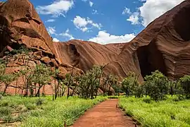
Muṯitjulu is an Indigenous Australian town in the Northern Territory. It is inside Uluṟu-Kata Tjuṯa National Park, just east of Uluṟu. It is named after a knee-shaped waterhole at the base of Uluṟu. Its people are mostly Pitjantjatjara. There are also some Yankunytjnatjara, Luritja and Ngaanyatjarra families living there. Almost everybody works in the national park.
| Mutitjulu Northern Territory | |||||||||
|---|---|---|---|---|---|---|---|---|---|
 | |||||||||
 Mutitjulu | |||||||||
| Coordinates | 25°21′03″S 131°03′59″E | ||||||||
| Population | 296 (2011 census) | ||||||||
| Postcode(s) | 0872 | ||||||||
| Elevation | 523 m (1,716 ft) | ||||||||
| Location |
| ||||||||
| LGA(s) | MacDonnell Shire | ||||||||
| Territory electorate(s) | Namatjira | ||||||||
| Federal division(s) | Lingiari | ||||||||
| |||||||||
The community had a population of 283 in the 2006 census.[1] It was reported to have dropped to around 150 in 2012, after alcohol was banned.[2]
References
- Australian Bureau of Statistics (25 October 2007). "Mutitjulu (Indigenous Area)". 2006 Census QuickStats. Retrieved 27 January 2012.
- Rothwell, Nicolas (4 August 2012). "Revolution's mosaic of success and failure". The Australian. Retrieved 27 November 2012.
Other websites
- Mutitjulu at WARU Archived 2005-02-16 at the Wayback Machine
- Mutijulu Community Council at ATNS Archived 2006-05-20 at the Wayback Machine
This article is issued from Wikipedia. The text is licensed under Creative Commons - Attribution - Sharealike. Additional terms may apply for the media files.