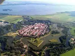
Naarden
Naarden was a municipality in the Dutch province of North Holland. Since 2016, it has been part of the new Gooise Meren municipality.
Naarden | |
|---|---|
Former municipality | |
 | |
 Flag  Coat of arms | |
.svg.png.webp) Location in North Holland | |
| Coordinates: 52°17′43″N 05°09′44″E | |
| Country | |
| Province | |
| Municipality | Gooise Meren |
| Area | |
| • Total | 32.90 km2 (12.70 sq mi) |
| • Land | 21.40 km2 (8.26 sq mi) |
| • Water | 11.50 km2 (4.44 sq mi) |
| Elevation | 3 m (10 ft) |
| Population (January 2019)[3] | |
| • Total | data missing |
| Demonym(s) | Naardenees, Naardenaar |
| Time zone | UTC+1 (CET) |
| • Summer (DST) | UTC+2 (CEST) |
| Postcode | 1410–1414 |
| Area code | 035 |
| Website | www |
References
- "Kerncijfers wijken en buurten 2020" [Key figures for neighbourhoods 2020]. StatLine (in Dutch). CBS. 24 July 2020. Retrieved 19 September 2020.
- "Postcodetool for 1411EC". Actueel Hoogtebestand Nederland (in Dutch). Het Waterschapshuis. Retrieved 19 March 2014.
- "Bevolkingsontwikkeling; regio per maand" [Population growth; regions per month]. CBS Statline (in Dutch). CBS. 1 January 2019. Retrieved 1 January 2019.
This article is issued from Wikipedia. The text is licensed under Creative Commons - Attribution - Sharealike. Additional terms may apply for the media files.