List of protected areas of British Columbia
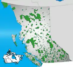
The following list of protected areas of British Columbia includes all federally and provincially protected areas within the Canadian province of British Columbia. As of 2015, approximately 15.46% of the province's land area and 3.17% of the province's waters are protected.[1]
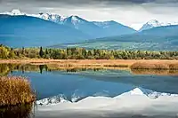
| Protected Lands & Waters in British Columbia | ||
|
| ||
| Statistics (2015)[1] | ||
| Type | Area | |
|---|---|---|
| Land | Water | |
| National Protected Areas | 0.7% | 2.2% |
| BC Parks | 14.4% | 0.9% |
| BC Conservation Lands | 0.26% | 0.07% |
| NGO Conservation Lands | 0.1% | – |
| Part of a series on |
| Canadian wildlife |
|---|
International recognition

Three UNESCO World Heritage Sites are entirely or partially located in British Columbia:
- Canadian Rocky Mountain Parks (shared with Alberta)
- Kluane / Wrangell–St. Elias / Glacier Bay / Tatshenshini-Alsek (shared with Yukon and Alaska, United States)
- SG̱ang Gwaay
Two UNESCO-MAB Biosphere Reserves are in British Columbia:
- Clayoquot Sound
- Mount Arrowsmith
Federally protected areas
Parks Canada
Seven National Parks of Canada are located in British Columbia, more than any other province or territory:
- Glacier National Park
- Gulf Islands National Park Reserve
- Gwaii Haanas National Park Reserve
- Kootenay National Park
- Mount Revelstoke National Park
- Pacific Rim National Park Reserve
- South Okanagan—Similkameen National Park Reserve (proposed)
- Yoho National Park
One National Marine Conservation Area of Canada is located in British Columbia:
- Gwaii Haanas Reserve
- Southern Strait of Georgia Reserve (proposed)
There are numerous National Historic Sites of Canada in British Columbia, with 13 being operated by Parks Canada:
Canadian Wildlife Service
Six National Wildlife Areas of Canada are located in British Columbia:
- Alaksen
- Columbia
- Qualicum
- Scott Islands Marine
- Vaseux-Bighorn
- Widgeon Valley
Seven Migratory Bird Sanctuaries of Canada are located in British Columbia:
- Christie Islet
- Esquimalt Lagoon
- George C. Reifel
- Nechako River
- Shoal Harbour
- Vaseux Lake
- Victoria Harbour
Fisheries and Oceans Canada
Three Marine Protected Areas of Canada are located in British Columbia:
- Endeavour Hydrothermal Vents
- Hecate Strait and Queen Charlotte Sound Glass Sponge Reefs
- SGaan Kinghlas-Bowie Seamount
Three Marine Refuges of Canada are located in British Columbia:
- Gwaxdlala/Nalaxdlala (Lull/Hoeya)[2]
- Offshore Pacific Seamounts and Vents
- Strait of Georgia and Howe Sound Glass Sponge Reef
Provincially protected areas
Ministry of Forests, Lands, Natural Resource Operations and Rural Development
The British Columbia Ministry of Forests, Lands, Natural Resource Operations and Rural Development (FLNRORD) manages a system of 31 Wildlife Management Areas throughout the province:
- Bert Brink
- Boundary Bay
- Chilanko Marsh
- Cluxewe
- Columbia Wetlands
- Coquitlam River
- Cranberry Marsh/Starratt
- Dewdrop-Rosseau Creek
- East Side Columbia Lake
- Green Mountain
- Great Bear Rainforest
- Hamling Lakes
- Lhá:lt/Harrison-Chehalis
- Lazo Marsh-North East Comox
- McTaggart-Cowan/Nsək'łniw't
- Midge Creek
- Parksville-Qualicum Beach
- Pemberton Wetlands
- Pitt-Addington Marsh
- Quatse Estuary
- Roberts Bank
- S'amunu
- Serpentine
- Skwelwil'em Squamish Estuary
- South Arm Marshes
- South Okanagan
- Stellako River
- Sturgeon Bank
- Swan Lake
- Todagin
- Tofino Mudflats
- Tranquille
See also
- List of municipal and regional parks in British Columbia
References
- "Protected Lands & Waters - Environmental Reporting BC". www.env.gov.bc.ca. Retrieved 14 October 2020.
- "Gwaxdlala/Nalaxdlala (Lull/Hoeya) marine refuge". Government of Canada. Retrieved 14 July 2023.
External links
- BC Parks - A complete list of BC Parks managed land.
Protected areas of Canada (by province or territory) | |
|---|---|
| Provinces |
|
| Territories |
|
| |
| |||||||||||||||||||||||||||||||||||||||||||||||||||||||||||||||||||||||||
| |||||||||||||||||||||||||||||||||||||||||||||||||||||||||||||||||||||||||
| |||||||||||||||||||||||||||||||||||||||||||||||||||||||||||||||||||||||||
| |||||||||||||||||||||||||||||||||||||||||||||||||||||||||||||||||||||||||
| |||||||||||||||||||||||||||||||||||||||||||||||||||||||||||||||||||||||||
| |||||||||||||||||||||||||||||||||||||||||||||||||||||||||||||||||||||||||
| |||||||||||||||||||||||||||||||||||||||||||||||||||||||||||||||||||||||||
| |||||||||||||||||||||||||||||||||||||||||||||||||||||||||||||||||||||||||
| |||||||||||||||||||||||||||||||||||||||||||||||||||||||||||||||||||||||||