Chinandega Department
Chinandega (Spanish pronunciation: [tʃinanˈdeɣa]) is a department in Nicaragua, located on the border with Honduras. It covers an area of 4,822 km2 and has a population of 441,897 (2021 estimate). The indigenous inhabitants of Chinandega are the Chorotegas and the Nahuas, and was the location of the pre-Columbian Nahua kingdom of Tezoatega.[2][3][4] The capital is the city of Chinandega.
Chinandega | |
|---|---|
 Flag | |
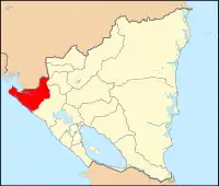 Chinandega, department of Nicaragua | |
| Country | Nicaragua |
| Capital | Chinandega |
| Area | |
| • Department | 4,822 km2 (1,862 sq mi) |
| Population (2021 estimate)[1] | |
| • Department | 441,897 |
| • Density | 92/km2 (240/sq mi) |
| • Urban | 288,830 |
| ISO 3166 code | NI-CI |
Largely agricultural, it produces rum from sugar cane; other products are bananas, peanuts, shrimp and salt.
The port of Corinto, in Chinandega, is the most important in Western Nicaragua.
Municipalities
- Chichigalpa
- Chinandega
- Corinto
- El Realejo
- El Viejo
- Posoltega
- Puerto Morazán
- San Francisco del Norte
- San Juan de Cinco Pinos
- San Pedro del Norte
- Santo Tomás del Norte
- Somotillo
- Villanueva
References
- [ "Nicaragua: Departments, Major Cities & Towns - Population Statistics, Maps, Charts, Weather and Web Information". www.citypopulation.de. Retrieved 2023-07-05.
- "Chorotegas".
- "Races of Chinandega".
- Fernández de Oviedo y Valdés, Gonzalo, Historia General y Natural de las Indias, pag. 127., tomo XI, Editorial Guarania. Asunción, Paraguay, 1945.
This article is issued from Wikipedia. The text is licensed under Creative Commons - Attribution - Sharealike. Additional terms may apply for the media files.