Dobong District
Dobong District (Korean: 도봉구; Hanja: 道峰區; RR: Dobong-gu) is one of the 25 districts of Seoul, South Korea. As of 2020, Dobong has a population of 315,979 and an area of 20.71 square kilometres (8.00 sq mi), and is divided into four administrative neighborhoods. The district is located in northeastern Seoul, bordering the Gyeonggi Province cities of Yangju and Uijeongbu to the north, and the districts of Gangbuk to the southwest and Nowon to the east.
Dobong
도봉구 | |
|---|---|
| 도봉구 · 道峰區 | |
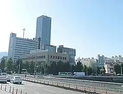 Skyline of Chang-dong | |
 Flag | |
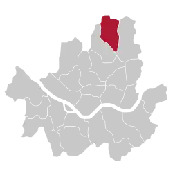 Location of Dobong-gu in Seoul | |
| Coordinates: 37°41′42″N 127°02′49″E | |
| Country | South Korea |
| Region | Sudogwon |
| Special City | Seoul |
| Administrative dong | 14 |
| Government | |
| • Body | Dobong District Council |
| • Mayor | Oh Un-seok (오언석) (People Power) |
| • MNAs | List of MNAs |
| Area | |
| • Total | 20.8 km2 (8.0 sq mi) |
| Population (2024[1]) | |
| • Total | 308,722 |
| • Density | 15,000/km2 (38,000/sq mi) |
| Time zone | UTC+9 (Korea Standard Time) |
| Postal code | 01300~01599 |
| Area code | 02-9xx,2000~ |
| Website | Dobong-gu official website |
History
Dobong District was created in 1973 by splitting 22 administrative neighborhoods off from Seongbuk District. By 1979, some of these 22 original administrative neighborhoods had been subdivided, increasing the number of administrative neighborhoods in Dobong District to 35.[2] In 1988, the sixteen administrative neighborhoods in Dobong-dong, Chang-dong, Wolgye-dong, Gongneung-dong, Hagye-dong, Junggye-dong, and Sanggye-dong were split off to form Nowon District, though the following year Dobong-dong and Chang-dong were returned to Dobong District.[3] Then in 1995, the 18 administrative neighborhoods in Mia-dong, Suyu-dong, and Beon-dong were split off to form Gangbuk District, leaving Dobong District with its present 14 administrative neighborhoods.[2]
Mountain
Dobongsan (Dobong Mountain) is a mountain in Bukhansan National Park, partly under the jurisdiction of Dobong-gu. It is a popular leisure spot for district residents.
In addition, Dobongsan has many large and small temples such as Cheonchuksa, Wontongsa, and Manweolam.[4]
Administrative divisions
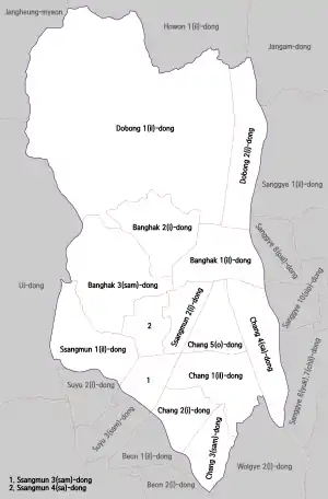
Dobong-gu is composed of four legal-status neighborhoods (법정동) which comprise a total of 14 administrative neighborhoods:
- Dobong-dong (도봉동 道峰洞) 1, 2
- Banghak-dong (방학동 放鶴洞) 1, 2, 3
- Ssangmun-dong (쌍문동 雙門洞) 1, 2, 3, 4
- Chang-dong (창동 倉洞) 1, 2, 3, 4, 5
Transportation
Railroad
- Korail
- Seoul Metro
- Seoul Subway Line 4
- (Nowon-gu) ← Chang-dong — Ssangmun → (Gangbuk-gu)
- Seoul Subway Line 4
- Seoul Metropolitan Rapid Transit Corporation
Education
- Jawoon High School (2004)
- Duksung Women's University
Sister cities
Notable people
- Lee Tae-min (born 1993), singer-songwriter, dancer, actor, and member of SHINee and SuperM
- Lee Seung-gi (born 1987), singer, actor, host, and entertainer
- Son Hyun-woo (손현우, born 1992), singer, dancer, actor, and member of Monsta X
- Yoon San-ha (윤산하, born 2000), singer and member of Astro
References
- Korean Statistical Information Service (Korean) > Population and Household > Census Result (2010) > Population by Administrative district, Sex and Age / Alien by Administrative district and Sex, Retrieved 2010-06-02.
- "도봉구(道峰區)" [Dobong-gu]. Encyclopedia of Korean Culture. Academy of Korean Studies. Retrieved 20 September 2020.
- "노원구(蘆原區)" [Nowon-gu]. Encyclopedia of Korean Culture. Academy of Korean Studies. Retrieved 25 September 2020.
- "DOBONG-GU OFFICE". eng.dobong.go.kr.
External links
- Official site (in Korean)
- Official site (in English)
| Districts |
| |||||
|---|---|---|---|---|---|---|
| Business districts | ||||||