List of islands of Bermuda
Bermuda is an archipelago consisting of 181 islands.
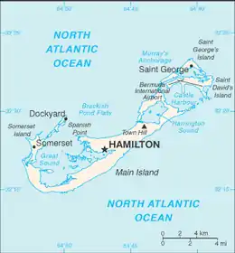 A map of the Bermuda Islands | |
| Administration | |
|---|---|
United Kingdom |
List of islands
| Name | Image | Coordinates | Parish | Note |
|---|---|---|---|---|
| Agar's Island | 32°17′38″N 64°48′33″W | Pembroke | In Great Sound. Was owned by billionaire James Martin, and was historically a secret munitions store, part of the Bermuda Garrison of the British Army. | |
| Alpha Island | 32°17′04″N 64°49′55″W | Warwick | In Great Sound. Also known as Diving Board Island as it is a popular spot for cliff jumping. | |
| Banjo Island | 32°22′33″N 64°41′36″W | St. George's | In Mullet Bay, St. George's Island. Also known as Bartram Island. | |
| Bartlett's Islands | 32°15′25″N 64°50′14″W | Southampton | In Little Sound. Two islands connected by a natural causeway. | |
| Bay Island | 32°21′02″N 64°43′32″W | Hamilton | In Bailey's Bay. | |
| Bermuda Island (Main Island) | 32°18′00″N 64°46′00″W | Several parishes | Central Bermuda, in main chain. Largest of the Bermuda Islands. | |
| Beta Island | 32°16′55″N 64°49′40″W | Warwick | In Great Sound. | |
| Bethell's Island | 32°18′07″N 64°52′46″W | Sandys | At the entrance to Ely's Harbour. | |
| Bird Island | 32°17′47″N 64°48′32″W | Pembroke | In Great Sound. | |
| Bird Rock | 32°20′15″N 64°40′12″W | St. George's | In mouth of Castle Harbour. | |
| Bluck's Island | 32°17′10″N 64°48′35″W | Warwick | In Great Sound. Formerly Dyer('s) Island, Denslow('s) Island. | |
| Boaz Island | 32°18′22″N 64°51′23″W | Sandys | Northwest Bermuda, in main chain. Formerly known as Gate's Island or Yates Island. | |
| Brangman's Fort | 32°20′32″N 64°40′03″W | St. George's | In mouth of Castle Harbour. | |
| Brooks Island | 32°22′18″N 64°40′30″W | St. George's | In St. George's Harbour. | |
| Buck Island | 32°15′26″N 64°51′32″W | Southampton | In Little Sound. | |
| Burnt Island | 32°17′03″N 64°47′44″W | Paget | In Hamilton Harbour. | |
| Burt Island, Warwick | 32°16′32″N 64°49′32″W | Warwick | In Great Sound. | |
| Burt's Island, Saint George's | 32°22′14″N 64°40′18″W | St. George's | In St. George's Harbour. | |
| Castle Island | 32°20′27″N 64°40′20″W | St. George's | In mouth of Castle Harbour. | |
| Cat Island | Pembroke | In Great Sound. | ||
| Cave Island | 32°21′50″N 64°41′17″W | St. George's | Now incorporated into Saint David's Island. | |
| Charles Island | 32°20′19″N 64°40′16″W | St. George's | In mouth of Castle Harbour. | |
| Cobbler's Island | 32°18′30″N 64°49′08″W | Pembroke | At the entrance to Great Sound. | |
| Coney Island | 32°21′30″N 64°42′55″W | St. George's | Off the northern tip of the main island. | |
| Cooper Island | 32°21′10″N 64°40′30″W | St. George's | Now incorporated into Saint David's Island. Also known as Cooper's Island. | |
| Crawl Island | 32°18′43″N 64°50′42″W | Sandys | Off the coast of Ireland Island. | |
| Cross Island | 32°19′31″N 64°50′09″W | Sandys | Part of the Royal Naval Dockyard. Now connected to Ireland Island and largely reclaimed. | |
| Crow Island | 32°20′02″N 64°43′31″W | Hamilton | In Harrington Sound. Also known as Easmos' Island. | |
| Current Island | 32°18′22″N 64°51′28″W | Sandys | Off the coast of Watford Island. | |
| Daniel's Island | 32°18′20″N 64°52′57″W | Sandys | Off the west coast of Somerset Island. | |
| Darrell's Island | 32°16′30″N 64°49′15″W | Warwick | In Great Sound. | |
| Delta Island | 32°16′51″N 64°49′27″W | Warwick | In Great Sound. | |
| Doctor's Island | 32°17′08″N 64°47′50″W | Paget | In Hamilton Harbour. | |
| Epsilon Island | 32°16′52″N 64°49′21″W | Warwick | In Great Sound. | |
| Eta Island | 32°17′05″N 64°49′06″W | Warwick | In Great Sound. | |
| Fern Island | 32°17′01″N 64°48′58″W | Warwick | In Great Sound. | |
| Ferry Island | 32°21′43″N 64°42′50″W | St. George's | Off the southern tip of St. George's Island. | |
| Five Star Island | 32°15′22″N 64°50′37″W | Southampton | In Little Sound. | |
| Gamma Island | 32°16′53″N 64°49′35″W | Warwick | In Great Sound. | |
| Gibbet Island | 32°19′23″N 64°44′37″W | Smith's | At the mouth of Flatt's Inlet. Also known as Gallows Island. Connected to the main island at low tide by a natural causeway. | |
| Goat Island, Pembroke | 32°17′47″N 64°48′25″W | Pembroke | In Great Sound. | |
| Goat Island, Saint George's | 32°21′18″N 64°39′48″W | St. George's | In Castle Harbour. | |
| Godet Island, Paget | 32°16′47″N 64°48′04″W | Paget | In Great Sound. Not to be confused with the larger nearby Hinson's Island, formerly known as Godet's Island. | |
| Goose Island | 32°17′51″N 64°48′34″W | Pembroke | In Great Sound. | |
| Governor's Island | 32°22′19″N 64°39′28″W | St. George's | At the entrance to St. George's Harbour. | |
| Grace Island | 32°16′25″N 64°50′05″W | Warwick | In Great Sound. | |
| Grasbury's Island | 32°21′18″N 64°39′22″W | St. George's | Off east coast of Saint David's Island. | |
| Great Oswego Island | 32°22′01″N 64°39′41″W | St. George's | In Smith's Sound. | |
| Green Rock | 32°20′40″N 64°39′40″W | St. George's | In mouth of Castle Harbour. | |
| Grey's Island | 32°18′47″N 64°51′02″W | Sandys | Off the northern tip of Boaz Island. | |
| Haggis Island | 32°15′40″N 64°49′38″W | Southampton | In Little Sound. | |
| Hall Island | 32°20′21″N 64°42′46″W | Hamilton | In Harrington Sound. Also known as Hall's Island. | |
| Hawkins Island | 32°17′10″N 64°49′43″W | Warwick | In Great Sound. | |
| Hen Island | 32°22′33″N 64°40′16″W | St. George's | In St. George's Harbour. | |
| Heron Rock | 32°18′42″N 64°50′48″W | Sandys | Off the coast of Ireland Island. | |
| Higgs' Island | 32°22′40″N 64°39′45″W | St. George's | At the entrance to St. George's Harbour. | |
| Hinson Island, Paget | 32°16′55″N 64°48′10″W | Paget | In Great Sound. Formerly called Godet's Island, and part of Warwick Parish. | |
| Hinson's Island, Pembroke | 32°17′58″N 64°48′34″W | Pembroke | In Great Sound. | |
| Horn Rock | 32°20′36″N 64°39′59″W | St. George's | In mouth of Castle Harbour. | |
| Horseshoe Island | 32°22′39″N 64°39′52″W | St. George's | At the entrance to St. George's Harbour. | |
| Hospital Island | 32°18′45″N 64°50′45″W | Sandys | Off the coast of Ireland Island. | |
| Idol Island | 32°20′44″N 64°39′40″W | St. George's | In mouth of Castle Harbour. | |
| Inner Island | 32°18′40″N 64°51′50″W | Sandys | Off the north coast of Somerset Island. Also known as Inner King's Point. | |
| Inner Pear Rock | 32°21′03″N 64°39′08″W | St. George's | Off southeast coast of Saint David's Island. | |
| Iota Island | 32°17′06″N 64°49′23″W | Warwick | In Great Sound. | |
| Ireland Island | 32°19′31″N 64°50′09″W | Sandys | Northwest Bermuda, in main chain. | |
| Irresistible Island | 32°16′55″N 64°48′46″W | Warwick | In Great Sound. | |
| Kerep Island | 32°17′14″N 64°49′32″W | Warwick | In Great Sound. Also known as Kappa Rock. | |
| Lambda Island | 32°17′20″N 64°49′50″W | Warwick | In Great Sound. | |
| Lefroy Island | 32°17′28″N 64°48′42″W | Pembroke | In Great Sound. | |
| Little Oswego Island | 32°22′03″N 64°39′38″W | St. George's | In Smith's Sound. | |
| Little Rogue's Island | 32°21′57″N 64°42′27″W | St. George's | Off southern St. George's Island. | |
| Long Bird Island | 32°21′53″N 64°41′50″W | St. George's | Now incorporated into Saint David's Island. | |
| Long Island, Saint George's | 32°21′45″N 64°40′32″W | St. George's | Now incorporated into Saint David's Island. | |
| Long Island, Warwick | 32°17′10″N 64°49′10″W | Warwick | In Great Sound. | |
| Long Rock | 32°21′26″N 64°39′17″W | St. George's | Off east coast of Saint David's Island. | |
| Malabar Island | 32°18′43″N 64°51′07″W | Sandys | Off the coast of Boaz Island. | |
| Marshall Island, Warwick | 32°17′00″N 64°48′34″W | Warwick | In Great Sound. | |
| Middle Island | 32°18′43″N 64°51′45″W | Sandys | Off the north coast of Somerset Island. Also known as Middle King's Point. | |
| Moresby's Island | 32°19′05″N 64°50′29″W | Sandys | Off the coast of Ireland Island. | |
| Morgan's Island, Ely's Harbour | 32°17′15″N 64°52′40″W | Sandys | At the entrance to Ely's Harbour. | |
| Morgan's Island, Great Sound | 32°16′15″N 64°51′00″W | Sandys | Now incorporated into the main island as Morgan's Point. | |
| Mount Island | 32°18′27″N 64°48′48″W | Pembroke | On north coast of main island, north of Spanish Point. | |
| Mouse Island | 32°18′04″N 64°48′34″W | Pembroke | In Great Sound, south of Spanish Point. | |
| Nelly Island | 32°17′05″N 64°49′28″W | Warwick | In Great Sound. | |
| No Name Island | 32°17′02″N 64°48′52″W | Warwick | In Great Sound. | |
| Nonsuch Island | 32°20′52″N 64°39′48″W | St. George's | In mouth of Castle Harbour. Formerly called Nonesuch Island. | |
| One Tree Island | 32°18′34″N 64°51′48″W | Sandys | Off the north coast of Somerset Island. | |
| Ordnance Island | 32°22′49″N 64°40′35″W | St. George's (town) | In St. George's Harbour. | |
| Outer Island | 32°18′45″N 64°51′42″W | Sandys | Off the north coast of Somerset Island. Also known as Outer King's Point. | |
| Outer Pear Rock | 32°20′55″N 64°39′03″W | St. George's | Off southeast coast of Saint David's Island. | |
| Paget Island | 32°22′30″N 64°39′35″W | St. George's | At the entrance to St. George's Harbour. | |
| Palm Island | 32°18′11″N 64°52′44″W | Sandys | At the entrance to Ely's Harbour. | |
| Partridge Island | 32°17′54″N 64°48′32″W | Pembroke | In Great Sound. | |
| Pearl Island | 32°17′30″N 64°50′14″W | Warwick | In Great Sound. | |
| Peggy's Island | 32°22′30″N 64°40′15″W | St. George's | In St. George's Harbour. | |
| Perot Island | 32°15′38″N 64°49′49″W | Southampton | In Little Sound. | |
| Ports Island | 32°17′00″N 64°49′15″W | Warwick | In Great Sound. | |
| The Quintons | 32°18′50″N 64°51′31″W | Sandys | Low-lying reef islands north of Somerset Island. | |
| Rabbit Island | 32°19′58″N 64°43′48″W | Hamilton | In Harrington Sound. | |
| Regatta Island | 32°18′45″N 64°50′35″W | Sandys | Off the coast of Ireland Island. Sometimes referred to as The Regatta Island. | |
| Reid Island | 32°17′10″N 64°47′56″W | Paget | In Hamilton Harbour. | |
| Rickett's Island | 32°16′34″N 64°49′43″W | Warwick | In Great Sound. Also known as Alexi Island. | |
| Riddell's Island | 32°15′43″N 64°49′43″W | Southampton | In Little Sound. | |
| Rogue Island | 32°21′53″N 64°42′30″W | St. George's | Off southern St. George's Island. | |
| Rushy Island | 32°20′15″N 64°40′25″W | St. George's | In mouth of Castle Harbour. | |
| Saint David's Island | 32°22′00″N 64°40′30″W | St. George's | Northeast Bermuda. Easternmost island of main chain. | |
| Saint George's Island | 32°23′00″N 64°40′30″W | St. George's | Northeast Bermuda. Northernmost island of main chain. | |
| Saltus Island | 32°17′27″N 64°48′01″W | Pembroke | In Hamilton Harbour. | |
| Smith's Island | 32°22′15″N 64°39′50″W | St. George's | Largest island in St. George's Harbour. | |
| Somerset Island | 32°17′47″N 64°52′10″W | Sandys | Northwest Bermuda, in main chain. | |
| Spectacle Island, Paget | 32°17′15″N 64°48′04″W | Paget | In Hamilton Harbour. | |
| Spectacle Island, Southampton | 32°15′30″N 64°50′02″W | Southampton | In Little Sound. | |
| Theta Island | 32°17′09″N 64°48′58″W | Warwick | In Great Sound. | |
| Tilley Island | 32°18′29″N 64°48′55″W | Pembroke | On north coast of main island, north of Spanish Point. | |
| Trunk Island | 32°20′00″N 64°43′37″W | Hamilton | In Harrington Sound. | |
| Tucker's Island | 32°16′15″N 64°51′30″W | Sandys | Now incorporated into the main island as Morgan's Point. | |
| Turtle Island | 32°19′21″N 64°42′56″W | Smith's | In Harrington Sound. | |
| Verrill Island | 32°17′24″N 64°48′47″W | Pembroke | In Great Sound. | |
| Watford Island | 32°18′23″N 64°51′24″W | Sandys | Northwest Bermuda, in main chain. | |
| Watling Island | 32°17′07″N 64°48′27″W | Warwick | In Great Sound. | |
| Westcott Island | 32°21′43″N 64°40′19″W | St. George's | Now incorporated into Saint David's Island. | |
| Whale Island, Sandys | 32°16′42″N 64°52′54″W | Sandys | In Ely's Harbour. | |
| Whalers Island, Saint George's | 32°22′27″N 64°39′56″W | St. George's | In St. George's Harbour. | |
| White Island, Paget | 32°17′17″N 64°47′04″W | Paget | In Hamilton Harbour. Also called White's Island. | |
| Zeta Island | 32°16′52″N 64°49′12″W | Warwick | In Great Sound. | |
See also
External links
 Wikimedia Atlas of Bermuda
- Islands of Bermuda @ United Nations Environment Programme
- Island information @ WorldIslandInfo.com
- Islands description @ Bermuda-online.org
Bermuda articles | |||||||||||
|---|---|---|---|---|---|---|---|---|---|---|---|
| History |
|  | |||||||||
| Geography |
| ||||||||||
| Schools |
| ||||||||||
| Politics |
| ||||||||||
| Economy |
| ||||||||||
| Society |
| ||||||||||
| |||||||||||
This article is issued from Wikipedia. The text is licensed under Creative Commons - Attribution - Sharealike. Additional terms may apply for the media files.