East Halmahera Regency
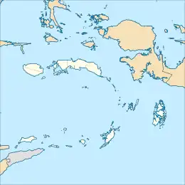
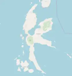
East Halmahera Regency (Indonesian: Kabupaten Halmahera Timur) is a regency of North Maluku Province of Indonesia, and occupies the northeastern peninsula of Halmahera island, together with the northern half of the southeastern peninsula of that island. It was created on 25 February 2003 from part of Central Halmahera Regency, and covers a land area of 6,515.74 km2. It had a population of 72,880 at the 2010 Census[2] and 91,707 at the 2020 Census;[3] the official estimate as at mid 2023 was 97,895 (comprising 50,563 males and 47,332 females).[1] The capital lies at the town of Maba in Kota Maba District.
East Halmahera Regency
Kabupaten Halmahera Timur | |
|---|---|
 Coat of arms | |
| Motto: Limabot Fayfiye | |
| Coordinates: 1.3352°N 128.4863°E | |
| Country | |
| Province | |
| Capital | Maba |
| Government | |
| • Regent | Rudy Erawan |
| • Vice Regent | Muh Din |
| Area | |
| • Total | 6,515.74 km2 (2,515.74 sq mi) |
| Population (mid 2023 estimate) | |
| • Total | 97,895 |
| • Density | 15/km2 (39/sq mi) |
| [1] | |
| Time zone | UTC+9 (IEST) |
| Area code | (+62) 921 |
| Website | haltimkab |
Administration
The regency is divided into ten districts (kecamatan), tabulated below with their areas and their populations at the 2010 Census[2] and the 2020 Census,[3] together with the official estimate as at mid 2023.[1] The table also includes the locations of the district administrative centres, the number of administrative villages (all rural desa) in each district, and its post code. The five Maba Districts comprise the southeastern half of the regency (and of the northeastern peninsula, together with that portion of the southeastern peninsula within the regency), while the five Wasile Districts comprise the northwestern half.
| Kode Wilayah | Name of District (kecamatan) | English name | Area in km2 | Pop'n Census 2010 | Pop'n Census 2020 | Pop'n Estimate mid 2023 | Admin centre | No. of villages | Post code |
|---|---|---|---|---|---|---|---|---|---|
| 82.06.03 | Maba Selatan | South Maba | 503.77 | 6,105 | 8,216 | 8,523 | Bicoli | 9 | 97861 |
| 82.06.10 | Kota Maba | Maba Town | 952.91 | 7,508 | 9,233 | 10,461 | Maba Sangaji | 6 | 97862 |
| 82.06.02 | Maba | 434.89 | 9,767 | 12,560 | 13,194 | Buli | 10 | 97860 | |
| 82.06.08 | Maba Tengah | Central Maba | 651.92 | 5,011 | 6,673 | 6,796 | Wayamli | 12 | 97863 |
| 82.06.09 | Maba Utara | North Maba | 1,118.73 | 7,113 | 8,588 | 9,202 | Dorosago | 12 | 97864 |
| 82.06.04 | Wasile Selatan | South Wasile | 1,078.41 | 10,999 | 13,269 | 14,514 | Nusa Jaya | 24 | 97866 |
| 82.06.01 | Wasile | 253.39 | 8,915 | 10,581 | 11,311 | Cemara Jaya | 7 | 97865 | |
| 82.06.07 | Wasile Timur | East Wasile | 431.05 | 8,676 | 11,979 | 11,983 | Dodaga | 8 | 97868 |
| 82.06.05 | Wasile Tengah | Central Wasile | 490.16 | 4,768 | 5,958 | 6,327 | Lolobata | 8 | 97867 |
| 82.06.06 | Wasile Utara | North Wasile | 600.51 | 4,247 | 5,196 | 5,588 | Labi-Labi | 8 | 97869 |
| Totals | 6,515.74 | 72,880 | 91,707 | 97,895 | Maba | 104 |
References
- Badan Pusat Statistik, Jakarta, 28 February 2024, Kabupaten Halmahera Timur Dalam Angka 2024 (Katalog-BPS 1102001.8206)
- Biro Pusat Statistik, Jakarta, 2011.
- Badan Pusat Statistik, Jakarta, 2021.
External links
 Media related to East Halmahera Regency at Wikimedia Commons
Regencies and cities of North Maluku | ||
|---|---|---|
Capital: Sofifi | ||
| Regencies |
| |
| Cities | ||